Disclosure : This site contains affiliate links to products. We may receive a commission for purchases made through these links.
Bristol Fishponds 1902

Bristol Fishponds in 1902 in a fascinating series of reproductions of old Ordnance Survey plans in the Alan Godfrey Editions, ideal for anyone interested in the history of their neighbourhood or family. The map covers the Fishponds, Ridgeway, Upper Eastville and Mayfield Park areas of Bristol. Features include tramways, Midland Railway with Stapleton (later Fishponds) station, Kingswood Junction, Hollybrook Brick Works, Chester Park area, Atlas Locomotive Works, Weighing Machine Works, Clay Hill, brick works, Greenbank Cemetery, St Mary`s church, St John`s Mission Church, Ridgeway Park Cemetery, Ridgeway House, part of Eastville Park, Clay Bottom, etc. An 1894 directory of Fishponds is on the reverseAbout the Alan Godfrey Editions of the 25″ OS SeriesSelected towns in Great Britain and Ireland are covered by maps showing the extent of urban development in the last decades of the 19th and early 20th century. The plans have been taken from the Ordnance Survey mapping and reprinted at about 15 inches to one mile (1:4,340). On the reverse most maps have historical notes and many also include extracts from contemporary directories. Most maps cover about one mile (1.6kms) north/south, one and a half miles (2.4kms) across; adjoining sheets can be combined to provide wider coverage.FOR MORE INFORMATION AND A COMPLETE LIST OF ALL AVAILABLE TITLES PLEASE CLICK ON THE SERIES LINK.

Related Products:
 Bristol (St George) 1902 – 72.14
Bristol (NE) 1902 – 72.13a
Bristol (SW) & Bedminster 1902 – 75.04a
Bristol Knowle 1902
Bristol (St George) 1902 – 72.14
Bristol (NE) 1902 – 72.13a
Bristol (SW) & Bedminster 1902 – 75.04a
Bristol Knowle 1902
 Brades Village 1902 68.13a
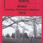 Bristol (Frenchay, Fishponds & Stapleton) 1912 – 72.06
Rowley Regis and Blackheath 1902
Bristol (Frenchay, Fishponds & Stapleton) 1912 – 72.06
Rowley Regis and Blackheath 1902
 Sheffield Hillsborough 1902
 Greets Green 1902
Langley and Londonderry 1902
West Bromwich 1902 – 68.10b
Sandwell Hall 1902
Belfast (East) 1902 – 4.11
Greets Green 1902
Langley and Londonderry 1902
West Bromwich 1902 – 68.10b
Sandwell Hall 1902
Belfast (East) 1902 – 4.11
 Cannock South 1902
 Great Bridge and Toll End 1902
Willesden and Stonebridge Park 1936
Griffin`s Hill 1902
Dundonald 1902
Worcester South-West 1902
Belfast Bloomfield 1902
Great Bridge and Toll End 1902
Willesden and Stonebridge Park 1936
Griffin`s Hill 1902
Dundonald 1902
Worcester South-West 1902
Belfast Bloomfield 1902
 Bloxwich 1902
Sydenham and Strandtown 1902
Fenton 1922
Bloxwich 1902
Sydenham and Strandtown 1902
Fenton 1922
 Sheffield Longley 1902
Leicester North West 1902
Belfast Knockdene Park 1902
Worcester North-East 1902
Ipswich 1902 – 75.11
Tenbury 1902
Sheffield Longley 1902
Leicester North West 1902
Belfast Knockdene Park 1902
Worcester North-East 1902
Ipswich 1902 – 75.11
Tenbury 1902
 The Falls 1931 – 60.12
Worcester North-West 1902
Ipswich South-West 1902
Rhosllanerchrugog 1909
Birmingham Central 1902-1911
Quinton 1902
Luton 1922 – 33.05
Gravelly Hill 1902
Shut End and Tansey Green 1903
East Jarrow 1913
Sheffield Park 1903
The Falls 1931 – 60.12
Worcester North-West 1902
Ipswich South-West 1902
Rhosllanerchrugog 1909
Birmingham Central 1902-1911
Quinton 1902
Luton 1922 – 33.05
Gravelly Hill 1902
Shut End and Tansey Green 1903
East Jarrow 1913
Sheffield Park 1903