Disclosure : This site contains affiliate links to products. We may receive a commission for purchases made through these links.
Brisbane Suburbs & City Centre UBD Gregory`s 418
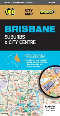
Brisbane Suburbs and City Centre map from UBD Gregory’s, combining a detailed, indexed street plan of the centre with a map of the city with its suburbs and the surrounding area, plus extensive tourist information,Half of one side is taken by a detailed, indexed street plan at 1:5,000 of the city centre (CBD) including the South Brisbane district with the Convention and exhibition centre. The plan shows one way streets, car parks, various facilities and places of interest, selected hotels, etc. Many individual buildings are named and streets are annotated with selected house numbers for easier identification of addresses. The rest of the page is filled with tourist information, including descriptions of ‘The Best of Brisbane” sights, notes on eating out and getting around, lists of accommodation and city highlights, events and festivals, etc.On the reverse is an indexed road map at 1:100,000 covering the city with its outer suburbs and the surrounding area. Coverage extends north beyond Redcliff, west to the D’Anguilar National Park and Ipswich, and south to Beenleigh. The map gives names of various districts and suburbs, and shows main traffic arteries across them. National parks and other protected nature areas are prominently highlighted.To see a list of other street plans and directories from UBD Gregory`s please click on the series link.

Related Products:
 Melbourne Suburbs & City Centre UBD Gregory`s 318
 Sydney Suburbs & City Centre UBD Gregory`s 218
 Brisbane UBD Gregory`s City Pocket 460
 Blue Mountains Suburban Streets UBD Gregory`s 290
 Brisbane City Streets & Suburbs UBD Gregory`s 462
 Sydney City Streets & Suburbs UBD Gregory`s 262
 Perth Suburbs & City Centre UBD Gregory`s 618
Adelaide Suburbs & City Centre UBD Gregory`s 518
Perth Suburbs & City Centre UBD Gregory`s 618
Adelaide Suburbs & City Centre UBD Gregory`s 518
 Melbourne UBD Gregory`s City Pocket 360
 Brisbane Hema
 Adelaide City Streets & Suburbs UBD Gregory`s 562
 Perth City Streets & Suburbs UBD Gregory`s 662
 Melbourne City Streets & Suburbs UBD Gregory`s 362
Brisbane to Cairns QLD UBD Gregory`s 444
Melbourne City Streets & Suburbs UBD Gregory`s 362
Brisbane to Cairns QLD UBD Gregory`s 444
 Brisbane & Queensland ITMB
 Canberra City Suburbs & South Coast NSW UBD Gregory`s 248
 Sydney & North Sydney UBD Gregory`s City Pocket 260
Australia: UBD Gregory`s Street Maps and Directories
Sydney & North Sydney UBD Gregory`s City Pocket 260
Australia: UBD Gregory`s Street Maps and Directories
 Dublin City Centre Tourist Map
 Copenhagen Borch
 South Australia State & Cities UBD Gregory`s 519
 New South Wales State & Cities UBD Gregory`s 219
 South Australia State & Suburban UBD Gregory`s 570
 Australia – State Capitals Street & Suburbs Hema
 Berlin Michelin City Map
 Krakow City Centre and Panorama TerraNostra Map
 Kiev F&B City Pocket
 Old City of Jerusalem Map
 Sydney to Brisbane Hema
 Salzburg F&B Tourist Street Plan
 South Island with 6 Town Centre Kiwimaps
 Geelong Suburban Streets VIC UBD Gregory`s 385
 Kaunas Jana Seta Street Plan
 Rome NGS City Destinations Map
 Barcelona Centre
 Granada Michelin City Map
 Brisbane to Cairns Hema
 Malaga Michelin City Map
 Budapest City Plan