Disclosure : This site contains affiliate links to products. We may receive a commission for purchases made through these links.
Brecon Beacons Harvey British Mountain Map XT40
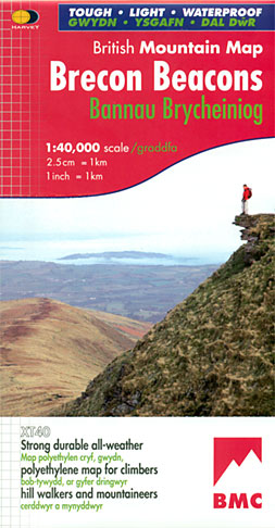
Waterproof mountain map of Brecon Beacons from Harvey at 1:40,000, with a geological map of the region on the reverse and advice on navigating the region safely.*MAIN MAP:* Topography is shown through clear altitude shading, spot heights, contours at 15m intervals, and index contours at 75m intervals. A variety of symbols are used to show terrain detail, such as caves/mines, major and climbing crags, shafts, sinkholes, cairns, and large boulders. The map is GPS compatible, with the National Grid overprinted on the cartography.Rights of way shown include tracks, long distance and intermittent paths. Road detail includes minor, residential and forest roads; railway lines and stops are marked, as are chairlifts and ski tows. Points of interest and facilities such as campsites, information points, and mountain rescue post are prominently highlighted.*GEOLOGICAL MAP:* The reverse shows a geological map of the region from the British Geological Survey, with detailed relief shading and colours used to denote different types of rock. There is additional written geological information, as well as a geological timeline of the region.*ADDITIONAL INFORMATION:* There is also information on mountain incident and first aid, navigating the region safely, and useful contact numbers are provided. There are also lists tourist information contacts, bunkhouses and hostels.The map text is both in English and Welsh.Printed on tough, hard-wearing polyethylene, the map is waterproof, tear-resistant, and comes in a clear plastic wallet.

Related Products:
 Southern Highlands Harvey British Mountain Map XT40
 Dartmoor Harvey British Mountain Map XT40
 Snowdonia South Harvey British Mountain Map XT40
 Cairngorms & Lochnagar Harvey British Mountain Map XT40
 Yorkshire Dales Harvey British Mountain Map XT40
 Ben Nevis & Glen Coe Harvey British Mountain Map XT40
 Lake District Harvey British Mountain Map XT40
 Dark Peak Harvey British Mountain Map XT40
 Knoydart – Kintail & Glen Affric Harvey British Mountain Map XT40
 Snowdonia North / Gogledd Eryri Harvey British Mountain Map XT40
 Great Britain: Harvey British Mountain Maps
 Schiehallion – Ben Lawers & Glen Lyon Harvey British Mountain Map XT40
 North York Moors Harvey British Mountain Map XT40
 White Peak Harvey British Mountain Map XT40
 Assynt & Coigach Harvey British Mountain Map XT40
 Brecon Beacons West Harvey Ultramap XT40
Brecon Beacons East Harvey Ultramap XT40
Torridon & Fisherfield Harvey British Mountain Map XT40
Brecon Beacons West Harvey Ultramap XT40
Brecon Beacons East Harvey Ultramap XT40
Torridon & Fisherfield Harvey British Mountain Map XT40
 Brecon Beacons Western & Central OS Explorer Active Map OL12 (waterproof)
 Brecon Beacons Western & Central OS Explorer Map OL12 (paper)
 Brecon Beacons Eastern OS Explorer Active Map OL13 (waterproof)
 Brecon Beacons Eastern OS Explorer Map OL13 (paper)
 Brecon Beacons OS Landranger Active Map 160 (waterproof)
 Brecon Beacons OS Landranger Map 160 (paper)
 Brecon Beacons East A-Z Adventure Atlas
 St Cuthbert`s Way Harvey National Trail XT40
 West & Central Brecon Beacons AA Walker`s Map 18
Cotswold Way Harvey National Trail XT40
West & Central Brecon Beacons AA Walker`s Map 18
Cotswold Way Harvey National Trail XT40
 Cumbria Way Harvey National Trail XT40
 Ben Nevis – Mamores & Grey Corries Harvey Ultramap XT40
 Glyndwr`s Way Harvey National Trail XT40
 South Downs Way Harvey National Trail XT40
 East Highland Way Harvey National Trail XT40
Speyside Way Harvey National Trail XT40
East Highland Way Harvey National Trail XT40
Speyside Way Harvey National Trail XT40
 Skye Trail Harvey National Trail XT40
Ridgeway Harvey National Trail XT40
Skye Trail Harvey National Trail XT40
Ridgeway Harvey National Trail XT40
 Two Moors Way Harvey National Trail XT40
 Dales Way Harvey National Trail XT40