Disclosure : This site contains affiliate links to products. We may receive a commission for purchases made through these links.
Brecon Beacons / Bannau Brycheiniog 1901-1902

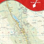
Map No. 160, Brecon Beacons / Bannau Brycheiniog 1901-1902, in the Cassini Historical Series of old Ordnance Survey mapping of England and Wales at 1:50,000 in a format designed to offer a convenient comparison with the present day coverage from the OS, and most locations in three different editions. Old historical maps have been combined so that the sheet lines correspond to the current Landranger series and reproduced with the scale changed from one inch to one mile to 1:50,000. Most locations are covered by three separate maps, showing how the area has changed over the decades, with selected major cities also presented in a fourth edition. * Old Series: the first detailed survey mapping dating for most areas from the first half of the 19th century, in black and white and with relief shown by hachuring.* Revised New Series from 1880s/1900s, with some colouring and a mixture of hachuring and contour lines.* Popular Edition from the inter-war years, with contour lines and colouring to indicate woodlands, parks, etc.* New Popular Edition from the late 1940s, reproduced in the Cassini series for the major cities.Each map includes notes on the development of Ordnance Survey and the various series produced by them. For those interested in maps and cartography in general, the Cassini series also provides a fascinating insight into how Ordnance Survey cartographic style has developed over a period of over 100 years.Coverage in this title includes present day Merthyr Tydfil/Merthyr Tudful, Brecon/Aberhondu, Llandovery/Llanymddyfri, Rhandirmwyn, Cilycwm, Cynghordy, Tirabad, Gewnddwr, Upper Chapel, Lower Chapel, Llandeilo’r-Fan, Llanwrda, Halfway, Llangadog, Myddfai, Pentre-bach, Soar, Trawscoed, Llanddew, Aberyscir, Sennybridge, Cwmwysg, Talsarn, Brynamman, Glyntawe, Abercraf, Cwmllynfell, Ystalyfera, Rhyd-y-fro, Seven Sisters/Blaendulais, Ystradfellte, Coelbren, Penderyn, Rhigos, and Hirwaun, with the Brecon Beacons National Park, The Black Mountain/Y Mynydd Du, Mynydd Epynt, and the peaks of Alt Lwyd, Carreg Yr Ogof, and Twyn Rhyd-car.* PLEASE NOTE: Stanfords can also print on request mapping from all four series *centring the map on a location of your choice.* For more information please click on the link below.

Related Products:
 Brecon Beacons / Bannau Brycheiniog 1919-1923
Kettering & Corby 1901-1902
Kidderminster & Wyre Forest 1901-1902
Lampeter and Llandovery / Llanbedr Pont Steffan a Llanymddyfri 1901-1902
Tenby and Pembroke / Dinbych-y-pysgod & Penfro 1901-1902
Cardigan and Mynydd Preseli / Aberteifi a Mynydd Preseli 1901
Skegness and Horncastle 1902-1903
Berwick-upon-Tweed 1901
Mansfield and Worksop 1902-1903
Porthmadog and Dolgellau 1902-1903
Haltwhistle and Brampton 1901-1904
Ely and Wisbech 1901
Cheviot Hills and Kielder Water 1901
Great Britain: Cassini Historical Reproductions of Ordnance Survey One-Inch Maps of England & Wales
Thetford and Diss 1901
St David`s and Haverfordwest / Tyddewi a Hwlffordd 1901-1912
Hexham and Haltwhistle 1901-1904
Peterborough 1901
Denbigh and Colwyn Bay / Dinbych a Bae Colwyn 1902-1903
West Cumbria 1901-1904
Brecon Beacons / Bannau Brycheiniog 1919-1923
Kettering & Corby 1901-1902
Kidderminster & Wyre Forest 1901-1902
Lampeter and Llandovery / Llanbedr Pont Steffan a Llanymddyfri 1901-1902
Tenby and Pembroke / Dinbych-y-pysgod & Penfro 1901-1902
Cardigan and Mynydd Preseli / Aberteifi a Mynydd Preseli 1901
Skegness and Horncastle 1902-1903
Berwick-upon-Tweed 1901
Mansfield and Worksop 1902-1903
Porthmadog and Dolgellau 1902-1903
Haltwhistle and Brampton 1901-1904
Ely and Wisbech 1901
Cheviot Hills and Kielder Water 1901
Great Britain: Cassini Historical Reproductions of Ordnance Survey One-Inch Maps of England & Wales
Thetford and Diss 1901
St David`s and Haverfordwest / Tyddewi a Hwlffordd 1901-1912
Hexham and Haltwhistle 1901-1904
Peterborough 1901
Denbigh and Colwyn Bay / Dinbych a Bae Colwyn 1902-1903
West Cumbria 1901-1904
 London 1920
Bala and Lake Vyrnwy / Y Bala a Llyn Efyrnwy 1902-1903
London 1897-1898
London 1945-1948
Cardigan and Mynydd Preseli / Aberteifi a Mynydd Preseli 1922-1923
Ludlow / Llwydlo & Church Stretton 1901-1903 – 137
Newtown and Llanidloes / Y Drenewydd a Llanidloes 1901-1903
London 1920
Bala and Lake Vyrnwy / Y Bala a Llyn Efyrnwy 1902-1903
London 1897-1898
London 1945-1948
Cardigan and Mynydd Preseli / Aberteifi a Mynydd Preseli 1922-1923
Ludlow / Llwydlo & Church Stretton 1901-1903 – 137
Newtown and Llanidloes / Y Drenewydd a Llanidloes 1901-1903
 Day Walks In the Brecon Beacons
Snowdon / Yr Wyddfa 1922
Snowdon / Yr Wyddfa 1903-1910
Anglesey / Mรดn 1922
Lleyn Peninsula / Pen Llyn 1922
Lleyn Peninsula / Pen Llyn 1903
Presteigne and Hay-on-Wye / Llanandras a’r Gelli Gandryll 1900-1903
Presteigne and Hay-on-Wye / Llanandras a’r Gelli Gandryll 1919-1920
Truro and Falmouth 1919
Land`s End and Isles of Scilly 1900
Ashford and Romney Marsh 1920-1921
Bournemouth and Purbeck 1811
Skegness and Horncastle 1824
Day Walks In the Brecon Beacons
Snowdon / Yr Wyddfa 1922
Snowdon / Yr Wyddfa 1903-1910
Anglesey / Mรดn 1922
Lleyn Peninsula / Pen Llyn 1922
Lleyn Peninsula / Pen Llyn 1903
Presteigne and Hay-on-Wye / Llanandras a’r Gelli Gandryll 1900-1903
Presteigne and Hay-on-Wye / Llanandras a’r Gelli Gandryll 1919-1920
Truro and Falmouth 1919
Land`s End and Isles of Scilly 1900
Ashford and Romney Marsh 1920-1921
Bournemouth and Purbeck 1811
Skegness and Horncastle 1824