Disclosure : This site contains affiliate links to products. We may receive a commission for purchases made through these links.
Brรผnigpass Swisstopo 37
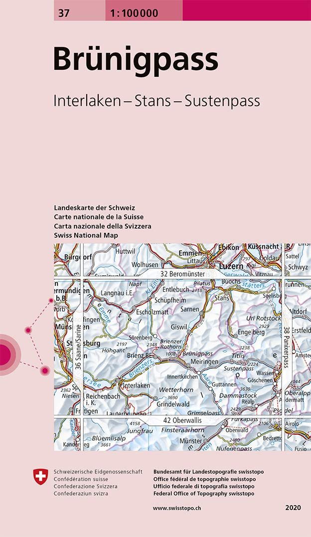
Swiss topographic survey at 1:100,000 from Swisstopo, highly regarded for it superb use of graphic relief and hill shading, presenting an almost 3-D picture of the country`s mountainous terrain. Coverage is available either as small size standard sheets ‘“ Nos 26 to 48, each covering 70 x 48 km / 43 x 30 miles approx, or as larger size maps – Nos. 101 onwards, each covering 100 x 70 km / 62 x 43 miles approx.Both formats have identical cartography, with contours at 50-metres intervals. Standard sheets include margin ticks showing latitude and longitude in steps of 10`, and both formats have an overprint showing the Swiss national grid lines at 10km intervals; latest editions of the larger sheets now have the Swiss grid lines at 1km intervals.Standard sheets have a map legend in the language of the area covered by the map. The larger sheets have no legend but a separate ‘Conventional Signs” leaflet in English can be provided with the map.To see the list of titles in this series please click on the series link.

Related Products:
 Basel Swisstopo 26
 Vorarlberg Swisstopo 34
 Flรผelapass Swisstopo 39
 Le Leman Swisstopo 40
 Oberwallis Swisstopo 42
 Val de Bagnes Swisstopo 46
 Besanรงon Swisstopo 30
 Beromรผnster Swisstopo 32
 Saane / Sarine Swisstopo 36
 Lindau Swisstopo 28bis
Bรถzberg Swisstopo 27
Lindau Swisstopo 28bis
Bรถzberg Swisstopo 27
 Toggenburg Swisstopo 33
Vallorbe Swisstopo 35
Toggenburg Swisstopo 33
Vallorbe Swisstopo 35
 Panixerpass Swisstopo 38
Col du Pillon Swisstopo 41
Sopra Ceneri Swisstopo 43
Panixerpass Swisstopo 38
Col du Pillon Swisstopo 41
Sopra Ceneri Swisstopo 43
 Haute-Savoie Swisstopo 45
 Sotto Ceneri Swisstopo 48
 Basel – Lucerne Swisstopo 102
Zurich – St. Gallen Swisstopo 103
Basel – Lucerne Swisstopo 102
Zurich – St. Gallen Swisstopo 103
 Lausanne – Bern Swisstopo 104
 Biel / Bienne Swisstopo 31
 Passo del Maloja Swisstopo 44
 Monte Rosa Swisstopo 47
 Glarnerland – Bundnerland Swisstopo 106
 Bodensee / Lake Constance Swisstopo 28
 Glarnerland, Bรผndnerland Swisstopo 106
 Ticino Swisstopo 107
 Thuner See – Central Switzerland Swisstopo 101
 Valais / Wallis Swisstopo 105
Switzerland: Swiss Survey 100K Topographic Maps
Valais / Wallis Swisstopo 105
Switzerland: Swiss Survey 100K Topographic Maps
 Lucerne – Pilatus – Rigi Swisstopo 2510
 Lรถtschental Swisstopo 2527
 Ofenpass Swisstopo 259
 Aletschgebiet Swisstopo 2516
 Napf Swisstopo 2522
Brusio Swisstopo 279
Gex Swisstopo 1280
Piz Lad Swisstopo 1199bis
Zug Swisstopo 1131
Napf Swisstopo 2522
Brusio Swisstopo 279
Gex Swisstopo 1280
Piz Lad Swisstopo 1199bis
Zug Swisstopo 1131