Disclosure : This site contains affiliate links to products. We may receive a commission for purchases made through these links.
Bowron Lakes Canoe Route ITMB
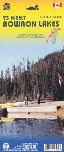
Bowron Lakes Canoe Route at 1:50,000 in a series of topographic survey maps of selected areas of British Columbia and the Canadian Rockies from ITMB with cartography from Canada’s national survey organization. Most sheets are printed on light, waterproof and tear- resistant plastic paper.Whilst the Canadian Department of Natural Resources (previously Canada Map Office) decides whether to provide updated pre-printed editions of its survey mapping or switch to print-on-demand only, in 2007 it began co-operating with ITMB on this new series of maps with cartography of the Canadian topographic survey and additional tourist and recreational information provided by ITMB. The maps are double-sided, with either two 1:50,000 maps combined in one title, or a 1:250,000 map supplemented by more detailed coverage at 1:50,000. *In this title:* Bowron Lakes are the result of an unusual geological fault, creating a diamond-shaped square in central British Columbia. The map, printed on light wateproof and tear-resistant plastic paper, combines four Canadian survey topographic sheets to chart the course of a canoe route along its 10 lakes. The map shows road access to the lakes and indicates various types of campsites and accommodation, recreational areas for hiking, horse riding, cross-country skiing, etc. Contours are at 100 feet intervals (conversion chart is provided).

Related Products:
 Tweedsmuir Provincial Park ITMB
Revelstoke National Park ITMB
Tweedsmuir Provincial Park ITMB
Revelstoke National Park ITMB
 Canadian Rockies – Banff – Kootenay – Yoho Parks ITMB
 Manning Park – Skagit River ITMB
Strathcona Plateau – Buttle Lake ITMB
Canada: ITMB/Canada Map Office Topographic Maps of British Columbia and the Rockies
North Vancouver – Port Coquitlam ITMB
Manning Park – Skagit River ITMB
Strathcona Plateau – Buttle Lake ITMB
Canada: ITMB/Canada Map Office Topographic Maps of British Columbia and the Rockies
North Vancouver – Port Coquitlam ITMB
 Garibaldi Provincial Park ITMB
Gulf Islands – Nanaimo and Islands ITMB
Wells Gray – Murtle Lake ITMB
Garibaldi Provincial Park ITMB
Gulf Islands – Nanaimo and Islands ITMB
Wells Gray – Murtle Lake ITMB
 West Coast Trail & Carmanah Valley ITMB
Lower Mainland – Richmond & New Westminster ITMB
West Coast Trail & Carmanah Valley ITMB
Lower Mainland – Richmond & New Westminster ITMB
 Algonquin Park ITMB
 Red Feather Lakes – Glendevey CO
 Mammoth Lakes – Mono Divide CA
 Great Lakes ITMB
 Glacier – Waterton Lakes National Park MT
 Fontana and Hiwasee Lakes – Nantahala National Forest NC NGS Trails Illustrated Map 784
 USA: Regional Coverage by ITMB Maps
 Alpine Lakes Wilderness – Mt Baker-Snoqualmie and Okanogan-Wenatchee National Forests WA
 South Holston and Watauga Lakes – Cherokee and Pisgah National Forest TN/NC
 Many Glacier – Glacier and Waterton Lakes National Parks MT
 Australia ITMB
 France ITMB
 Venezuela ITMB
 Bavarian Lakes Cycling Map
Franconian Lakes Cycling Map
Spreewald – Berlin Lakes Cycling Map
Bavarian Lakes Cycling Map
Franconian Lakes Cycling Map
Spreewald – Berlin Lakes Cycling Map
 Jungfrau Region – Lakes Thun and Brienz K+F Hiking Map 18
 Prince Edward Island ITMB
 Florida & US Deep South ITMB
 Canada: ITMB Detailed Road Maps of British Columbia and the Canadian Rockies
 English Lakes South Western – Coniston, Ulverston & Barrow-in-Furness OS Explorer Map OL6 (paper)
 Hawaii & Honolulu ITMB
 Iceland ITMB
 Reykjavik & SW Iceland ITMB
 Chicago & Lake Michigan ITMB
 Mecklenburg Lakes Cycle Route – Lรผneburg to Usedom Bikeline Map-Guide
 Turkey ITMB
 Thailand ITMB