Disclosure : This site contains affiliate links to products. We may receive a commission for purchases made through these links.
Bowditch Plus – Complete Navigator`s Library DVD (Version 5)
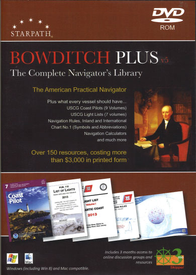
The American Practical Navigator, Pub. No. 9, now called “Bowditch Plus”. This publication is a DVD, no print book is included.Complete text and illustrations of this classic 800-page reference book on marine navigation, fully searchable and indexed, presented in convenient Adobe Acrobat Reader format (pdf). Bowditch Plus! includes the latest edition (2017) of this classic reference.World Sailing Directions:These are effectively the ‘Coast Pilots” of international waters made by the US. They include a wealth of navigation information for voyage planning in international waters and visiting foreign countries. Together with the Pilot charts they form the starting point for any international ocean voyage. Note the editions called Planning Charts are more general than those with specific regions named.Pilot Charts:Pilot Charts depict averages in prevailing winds and currents, air and sea temperatures, wave heights, ice limits, visibility, barometric pressure, and weather conditions at different times of the year. They also include great circle routes between major ports which is where navigators would expect more ship traffic. These charts and the associated Planning Guides and Sailing Directions are the starting point for planning ocean voyages. Note the variation data included may be outdated for the older editions.USCG Light Lists:A textbook for professional weather observers used by the ships working with the NWS. Includes much general and interesting information as well, such as explanations of old sayings, cloud identification, and so on.Navigation Table Data and Calculators:Besides the actual table data, convenient, dedicated calculators are provided to reproduce the Navigation Table data historically included in Pub. 9. These computations are presented using your web browser, Netscape or Internet Explorer. No interpolation necessary, simply enter the parameters and click “Compute.”Chart Symbols and Abbreviations:Called “Chart No. 1” by some, and “Chart H-5000” or “INT 1” by other nations, this is the complete presentation of all nautical chart symbols used internationally, conveniently indexed by name and graphic design.Navigation Rules:A complete, illustrated copy of the Rules of the Road (International and US Inland) presented in a fully searchable, easy to read electronic format. This document can be printed to reproduce the government edition. We also include a fully searchable copy of the extensive set of Canadian Modifications to the Rules.World Port Index:The complete World Port Index is provided in pdf format along with our own custom interface to it that lets you look up any port instantly by just typing its name. An index has also been created in case the spelling of a port name is uncertain.Distances Between Ports (Pub 151):Essentially a waypoint guide giving lat and lon of world ports and the great circle distances between them.Distances Between US Ports:Similar to Pub 151 for world ports, but limited to US coastal ports, including the Intracoastal Waterway, navigable river systems, and the Great Lakes.International Code of Signals (Pub 102):Covers all forms of signaling, still a required reference for ocean yacht racing. It is clearly valuable to know how to communicate visually or by code if need be. This book tells how.Radio Navigation Aids (Pub 117):A primary reference book for any radio equipped vessel. Especially valuable for world cruisers. Lists all services and frequencies, worldwide.Radar Navigation Manual (Pub 1310):A textbook on marine radar use and operation. A bit outdated in places, but still a primary reference used in radar schools today. This new edition also includes a complete copy of the book called Maneuvering Board Manual, Pub. 217, which covers methods of solving various vector problems.Worldwide Marine Radiofacsimile Broadcast Schedules:Frequencies, content, and times of broadcast for all weather fax broadcasts worldwide. This list is periodically updated and can be found online at the Oceans Prediction Center section of the NWS.Mariner`s Guide to Hurricane Awareness:A complete mini textbook on hurricanes written by Eric Holweg. Examples are from the North Atlantic, but useful information about all tropical cyclones. This is a NOAA publication.Navigation Calculators:More than 30 custom calculators for all aspects of navigation and weather. Originally individual items from NIMA, here built into a convenient package by Starpath.Electronic Coast Pilots:Presents crucial information for navigation that is not included on charts. Nine volumes of extensive and valuable information including weather and emergency services covers all US waters. These are mandatory references for any cruising.NIMA List of Lights:International list of lights and other nav aids from NIMA. The counterpart for US waters is published by USCG. These are annual publications that can be updated at www.nima.mil. List location and all characteristics of each aid.Sight Reduction Tables:For celestial navigation, includes complete copies of Pub 249 and Pub 229, which have been much enhanced with indexes and book marks by Starpath. Also includes a Starpath production of the NAO sight reduction tables, which are the ones included in the Nautical Almanac.Frequency ListA series of documents on frequencies for VHF and HF (SSB) radios. Includes both communications and services.NWS HandbookA textbook for professional weather observers used by the ships working with the NWS. Includes much general and interesting information as well, such as explanations of old sayings, cloud identification, and so on.MSC Charts:Marine Weather Services Charts. Covers all US waters in 13 charts. Each chart lists all sources and the locations of the reporting and broadcasting stations. A crucial reference for anyone who wants to get the most out of NWS data. The MSC charts are outdated in some respects and no longer available from NOAA, but they remain useful and can be printed and updated as needed from information available at the NWS marine weather site. The graphical plots of the forecast zones alone make them valuable.In short, the Bowditch Plus! DVD offers you some $3000 worth of books, all fully searchable, plus the convenience of 39 numerical calculators for navigation computations.


