Disclosure : This site contains affiliate links to products. We may receive a commission for purchases made through these links.
Bollington 1907
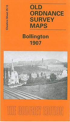
Bollington in 1907 in a fascinating series of reproductions of old Ordnance Survey plans in the Alan Godfrey Editions, ideal for anyone interested in the history of their neighbourhood or family. The map covers the village of Bollington, stretching from the railway station eastward to High Cliff and Ingersley Hall. Features include the village centre, St John`s church, Oak Bank Print Works, Lower Mill, Clarence Mill, River Dean, iron foundry, Waterhouse Mills, Adelphi Mill, Sowcar, etc. Coverage extends south to Kerridge and Gag Quarry. Other features include Waulkmill, Ingersley Vale Bleach Works, Rainow Mill, Ingersley Hall, Hollin Hall, Hurst Quarry etc. On the reverse is an 1896 directory of Bollington.About the Alan Godfrey Editions of the 25″ OS Series:Selected towns in Great Britain and Ireland are covered by maps showing the extent of urban development in the last decades of the 19th and early 20th century. The plans have been taken from the Ordnance Survey mapping and reprinted at about 15 inches to one mile (1:4,340). On the reverse most maps have historical notes and many also include extracts from contemporary directories. Most maps cover about one mile (1.6kms) north/south, one and a half miles (2.4kms) across; adjoining sheets can be combined to provide wider coverage.FOR MORE INFORMATION AND A COMPLETE LIST OF ALL AVAILABLE TITLES PLEASE CLICK ON THE SERIES LINK.

Related Products:
 Heywood 1907
 Blackrod 1907
Horwich North 1907
Hopwood Hall and Thornham 1907
Blackrod 1907
Horwich North 1907
Hopwood Hall and Thornham 1907
 Barnoldswick 1907
Westhoughton 1907
Accrington 1909
Barnoldswick 1907
Westhoughton 1907
Accrington 1909
 Newport 1907 – 95.02
 Lostock Junction 1907
Pedmore 1921
Wigan 1907 – 93.08b
Lostock Junction 1907
Pedmore 1921
Wigan 1907 – 93.08b
 Wickersley 1901
Boothstown and Astley Green 1904
Halifax Ovenden Cross 1905
Wickersley 1901
Boothstown and Astley Green 1904
Halifax Ovenden Cross 1905
 Chorley 1909
 Sevenoaks South 1907
 Hayes 1907
 Bradford East 1906
King`s Norton 1903
Horbury 1905
Gunnislake South and Albaston 1905
Burnhope 1895
Sacriston 1897
Bradford East 1906
King`s Norton 1903
Horbury 1905
Gunnislake South and Albaston 1905
Burnhope 1895
Sacriston 1897
 Workington South 1923
 Bootle 1907
 Tottington 1908
 Cannock South 1902
 Pendleton North 1915
 Sevenoaks North and Riverhead 1907
 New Hartley and Delaval Hall 1896
Oswaldtwistle and Church 1909
Bexenden 1909
Bromsgrove 1926
Leyland 1909
Lostock Hall and Farington North 1909
North Chorley 1909 – 77.08
Openshaw 1905
New Hartley and Delaval Hall 1896
Oswaldtwistle and Church 1909
Bexenden 1909
Bromsgrove 1926
Leyland 1909
Lostock Hall and Farington North 1909
North Chorley 1909 – 77.08
Openshaw 1905
 Openshaw 1916
 West Drayton South 1935
 Leeds (Harehills, Buslingthorpe & Chapeltown Road) 1919 – 203.14c