Disclosure : This site contains affiliate links to products. We may receive a commission for purchases made through these links.
Bloxwich 1902
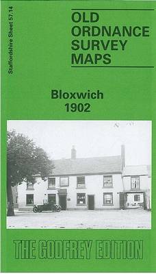
Bloxwich in 1902 in a fascinating series of reproductions of old Ordnance Survey plans in the Alan Godfrey Editions, ideal for anyone interested in the history of their neighbourhood or family. The map covers much of Bloxwich, north of Walsall, and also includes Little Bloxwich and Wallington Heath. Features include Elmore Green (at foot of map), Highfield House, section of railway (but no station), section of Wyrley & Essington Canal, Wallington House, Bloxwich Park, brewery, cemetery, old coal shafts, Baytree House, The Hills, Selmans Hill Farm, etc. A Bloxwich Directory from the Walsall Red Book is on the reverse.About the Alan Godfrey Editions of the 25″ OS Series:Selected towns in Great Britain and Ireland are covered by maps showing the extent of urban development in the last decades of the 19th and early 20th century. The plans have been taken from the Ordnance Survey mapping and reprinted at about 15 inches to one mile (1:4,340). On the reverse most maps have historical notes and many also include extracts from contemporary directories. Most maps cover about one mile (1.6kms) north/south, one and a half miles (2.4kms) across; adjoining sheets can be combined to provide wider coverage.FOR MORE INFORMATION AND A COMPLETE LIST OF ALL AVAILABLE TITLES PLEASE CLICK ON THE SERIES LINK.

Related Products:
 Carshalton & North Wallington 1910 – 13.12
Dundonald 1902
Carshalton & North Wallington 1910 – 13.12
Dundonald 1902
 Sandwell Hall 1902
 Sheffield Longley 1902
Shire Oak and Catshill 1901
Warley 1902
Bristol Knowle 1902
Griffin`s Hill 1902
Worcester North-West 1902
Tenbury 1902
Wednesbury 1902
Sheffield Longley 1902
Shire Oak and Catshill 1901
Warley 1902
Bristol Knowle 1902
Griffin`s Hill 1902
Worcester North-West 1902
Tenbury 1902
Wednesbury 1902
 Cannock South 1902
Quinton 1902
Belfast Knockdene Park 1902
Sydenham and Strandtown 1902
Wincobank & Meadowhall 1902 – 289.13a
Cannock South 1902
Quinton 1902
Belfast Knockdene Park 1902
Sydenham and Strandtown 1902
Wincobank & Meadowhall 1902 – 289.13a
 Sheffield Hillsborough 1902
Bristol Fishponds 1902
Bristol (St George) 1902 – 72.14
Sheffield Hillsborough 1902
Bristol Fishponds 1902
Bristol (St George) 1902 – 72.14
 Great Bridge and Toll End 1902
Rowley Regis and Blackheath 1902
Worcester South-West 1902
Great Bridge and Toll End 1902
Rowley Regis and Blackheath 1902
Worcester South-West 1902
 Bromley Common and North-East Hayes 1895
Wylde Green 1913
Langley and Londonderry 1902
Bromley Common and North-East Hayes 1895
Wylde Green 1913
Langley and Londonderry 1902
 Walsall (NE) 1913 – 63.07
Lenzie 1897
Brades Village 1902 68.13a
Willenhall North East 1885
Belfast Bloomfield 1902
Carmyle 1934
Bewdley 1926
Worcester North-East 1902
Glasgow North East 1893
Rothesay 1886 – 204.06
Belfast (East) 1902 – 4.11
Walsall (NE) 1913 – 63.07
Lenzie 1897
Brades Village 1902 68.13a
Willenhall North East 1885
Belfast Bloomfield 1902
Carmyle 1934
Bewdley 1926
Worcester North-East 1902
Glasgow North East 1893
Rothesay 1886 – 204.06
Belfast (East) 1902 – 4.11
 Mid Finchley 1934
 Mid Finchley 1911
 Warwick North 1923
Dun Laoghaire 1908
Warwick North 1923
Dun Laoghaire 1908