Disclosure : This site contains affiliate links to products. We may receive a commission for purchases made through these links.
Birmingham Greenways Cycle Map

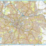
Birmingham Greenways Cycle Map at 1:30,000 showing 150 miles of traffic-free cycling paths around Birmingham and the Black Country. With central Birmingham on both sides of the map, coverage extends to Walsall, Sutton Coldfield, Solihull, Barnt Green, Halesowen, Dudley and Bilston. Highlighting for the routes indicates off-road/towpath sections, off-road poorer surface, paths adjacent to a main road, and linking routes, as well as points where special care or dismounting is required. Symbols show locations of various facilities and places of interest, and given the number of canals within this area, information includes canal locks, boat hire or trips, and watersport facilities. The map has lines at 500m with coordinates of the British National Grid and has an index of tourist attractions and heritage sites.The centre of Birmingham is shown in greater detail at 1:15,000 approx, with more facilities such as pubs, car parks, etc. The map is surrounded by colour photos and descriptions of places of interest, plus general notes about the history of the area.

Related Products:
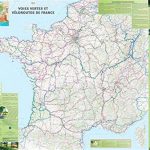
 France Greenways and Cycle Routes IGN Map 924
 50 Miles Around Birmingham A-Z Wall Map
 Birmingham – Walsall, Solihull & Redditch OS Explorer Map 220 (paper)
 Severn, Avon & Birmingham Collins Nicholson Waterways Guide 2
 Birmingham – Walsall, Solihull & Redditch OS Explorer Active Map 220 (waterproof)
 West Midlands – Birmingham – Coventry – Wolverhampton A-Z Street Atlas
 Grand Union Canal – Birmingham to Milton Keynes Heron Maps
 Birmingham – Dudley – Solihull – Walsall – Wolverhampton A-Z Big Street Atlas
 Waterways Guide 2 – Severn, Avon & Birmingham
 Birmingham Canal Navigations Heron Map
 Waterways Guide 3 – Birmingham and the Heart of England
 Walking the Grand Union Canal from London to Birmingham: 153 Mile Walk from the River Thames at Bentford to Gas Street Basin, Birmingham. Can be Done in 9 Stages
 Birmingham & the Heart of England Collins Nicholson Waterways Guide 3
 Birmingham A-Z Pocket Street Map
 France IGN Greenways and Cycle Routes Wall Map
 Birmingham AL Rand McNally
 Birmingham A-Z Street Atlas
 France Chamina Edition Greenways and Cycle Routes Atlas
 Birmingham, Wolverhampton & The Black Country OS Landranger Map 139 (paper)
 Birmingham, Wolverhampton & The Black Country OS Landranger Active Map 139 (waterproof)
 Birmingham A-Z Street Plan Wall Map
 Birmingham and West Midlands Railway Atlas
 Shropshire, Staffordshire & The Black Country 110K Sustrans Cycle Map No. 22
 Birmingham North 1913
 Birmingham Z-Map
Birmingham South 1913
Birmingham Z-Map
Birmingham South 1913
 Totnes & Dartmouth Cycle Map 62
 Yorkshire Dales Cycle Way
 Kattegattleden Cycle Route
 Birmingham Pevsner Architectural Guide
 Exmouth & Sidmouth Cycle Map 61
 The North West Trail Cycle Route
 Braunton & Ilfracombe Cycle Map 60 – with Tarka Trail & Barnstaple
 A-Z Birmingham Hidden Walks: Discover 20 routes in and around the city
 Aukstaitija National Park
 Lรดn Las Cymru Cycle Route North: Holyhead – Llanidloes
 Mallorca Publicpress Cycle Touring 152
 Danube-Lake Constance Cycle Route – Upper Swabia-Allgรคu Cycle Route Bikeline Map-Guide
 Lรดn Cambria & Lรดn Teifi: Mid-Wales Cycle Routes
 London Sustrans Cycle Map 53