Disclosure : This site contains affiliate links to products. We may receive a commission for purchases made through these links.
Biarritz – Bayonne – Anglet and their Environs IGN 88415
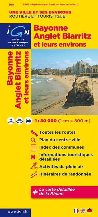
Biarritz – Bayonne – Anglet and their Environs in a series of detailed road maps at 1:80,000 from the IGN, designed to highlight places of interest and recreational possibilities, with a city centre street plan and an enlargement of a selected hiking area.Cartography is an enlargement from 1:100,000 to 1:80,000 of the publisher’s highly popular TOP100 series, with very detailed presentation of the road network, including classification of local roads according to lanes, rest areas, access restrictions, etc. Railway lines are shown with stations. Topography is shown by relief shading, with spot heights and colouring for woodlands, vineyards, orchards, etc. Cycle tracks and long-distance GR routes are marked. A wide range of symbols indicate various places of interest and recreational facilities, historical and cultural sites, golf courses, rock climbing, nature reserves, etc. Refuges and gรฎtes d’etape are marked, but no campsites. The maps have no geographical coordinates for GPS. Each title has an index of communes. Map legend includes English.A special feature of this series is the inclusion of a large city centre street plan and an enlargement of a particularly interesting recreational area. Presentation of these features varies, so please check the individual descriptions for more information.* IN THIS TITLE: a large street plan of the city centre of Biarritz highlighting main traffic arteries and indicating one way streets. An additional panel presents an extract from IGN’s topographic coverage of the area between Ascain and the peak of La Rhune in the Pyrenees in their TOP25 series but shown here at 1:30,000. The extract highlights local hiking routes. The map also indicates how its whole area is covered by IGN’s topographic survey at 1:25,000.

Related Products:
 Bayonne – Biarritz – Anglet Blay-Foldex Street Plan
 Rouen and its Environs IGN Map
 Metz and its Environs IGN Map
 Angers and its Environs IGN Map
 Nancy and its Environs IGN Map
 Perpignan and its Environs IGN Map
 Grenoble and its Environs IGN Map
 Tours and its Environs IGN Map
 Orlรฉans and its Environs IGN Map
 Nรฎmes and its Environs IGN Map
 Dijon and its Environs IGN Map
 Bayonne – Anglet – Biarritz – Cote d`Argent IGN 1344OT
 Pau and its Environs IGN Map
 Marseille and its Environs IGN 88404
 Limoges and its Environs IGN Map
 Mulhouse and its Environs IGN Map
 St-Etienne and its Environs IGN Map
 Toulouse and its Environs IGN 88414
 Rennes and its Environs IGN Map
 Nice and its Environs IGN Map
 Avignon and its Environs IGN 88426
 Toulon and its Environs IGN Map
 Strasbourg and its Environs IGN 88412
 France: IGN Maps of Environs of Main Cities
 Lyon and its Environs IGN 88403
 Valencia Michelin City Map
 Paris and its Environs IGN 88408
 Kaunas Jana Seta Street Plan WATERPROOF
 Kaunas Jana Seta Street Plan
 Lugo and Environs CNIG Map
 Ljubljana
 Munich F&B
 Munich F&B Wall Map
 Maribor
 Verona Global Map Street Plan
 Biarritz – Hendaye – la Rhune IGN Pocket Map M1244OT
 Florence Global Map Street Plan
 Munich F&B Wall Map – with Metal Hanging Strips
 Turin Global Map Street Plan
 Siena Global Map Street Plan