Disclosure : This site contains affiliate links to products. We may receive a commission for purchases made through these links.
Bexley Heath 1862
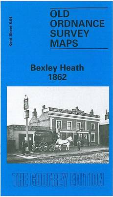
Bexley Heath in 1862 in a fascinating series of reproductions of old Ordnance Survey plans in the Alan Godfrey Editions, ideal for anyone interested in the history of their neighbourhood or family. The map covers what was still called Bexley Heath – the name did not become Bexleyheath until later in the century. Coverage extends from Crook Log and Upton Lane eastward to Gravel Hill and a little beyond. The principal feature of the map are the many houses in leafy gardens spread along the Dover Road, which goes west-east across it. Features include Mill Road with a corn windmill, Warren Farm, church, Essex Place, Markall Lane, and several pubs on the main road. Beyond this it remains a rural scene. A directory of Bexley Heath is on the reverse.About the Alan Godfrey Editions of the 25″ OS Series:Selected towns in Great Britain and Ireland are covered by maps showing the extent of urban development in the last decades of the 19th and early 20th century. The plans have been taken from the Ordnance Survey mapping and reprinted at about 15 inches to one mile (1:4,340). On the reverse most maps have historical notes and many also include extracts from contemporary directories. Most maps cover about one mile (1.6kms) north/south, one and a half miles (2.4kms) across; adjoining sheets can be combined to provide wider coverage.FOR MORE INFORMATION AND A COMPLETE LIST OF ALL AVAILABLE TITLES PLEASE CLICK ON THE SERIES LINK.

Related Products:
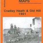 Cradley Heath and Old Hill 1901
 Newton Heath 1915
 Cheadle and Cheadle Heath 1897
 Thornton Heath and Norbury 1894
 Hampstead 1866 – 27.1
 Hampstead 1915 – 27.3
 Sheffield Longley 1902
Selly Oak and Bournville 1903
Wisbech 1900
Sheffield Longley 1902
Selly Oak and Bournville 1903
Wisbech 1900
 Snaresbrook 1939
 Leeds East 1906
Sheffield Park 1903
Leeds East 1906
Sheffield Park 1903
 Upper Edmonton 1894 – 3a
Coombeswood 1914
Harborne South 1901
Upper Edmonton 1894 – 3a
Coombeswood 1914
Harborne South 1901
 Handsworth 1913
Gateacre 1904
Wanstead 1915 – 24.3
Handsworth 1913
Gateacre 1904
Wanstead 1915 – 24.3
 Croydon East: Coombe Park & Addiscombe Road 1895 – 158
Hounslow West 1894 – 20.06a
Croydon East: Coombe Park & Addiscombe Road 1895 – 158
Hounslow West 1894 – 20.06a
 Cheetham & Higher Broughton 1915 – 104.02b
 Walton on the Hill 1906
Quinton 1902
North Shields and Chirton 1894
Maldon West 1920 – 55.16
Walton on the Hill 1906
Quinton 1902
North Shields and Chirton 1894
Maldon West 1920 – 55.16
 West Drayton South 1935
 Tottenham (North) 1894 – 8a
Timperley 1897
New Quay 1904
Tottenham (North) 1894 – 8a
Timperley 1897
New Quay 1904
 Hazel Grove 1897
 Bromley North and Sundridge Park 1895
 Hunmanby 1926
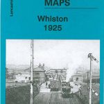 Whiston 1925
Jarrow 1912
Whiston 1925
Jarrow 1912
 Wavertree and Broad Green 1905
Anfield 1908 – 106.07b
Wavertree and Broad Green 1905
Anfield 1908 – 106.07b
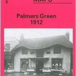 Palmers Green 1912 – 7.14a
 South Norwood 1895
Easington Lane and Bryn Gates 1896
East Boldon 1895
South Norwood 1895
Easington Lane and Bryn Gates 1896
East Boldon 1895