Disclosure : This site contains affiliate links to products. We may receive a commission for purchases made through these links.
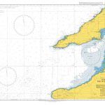
Betlem – Cap Ferrutx 25K Mallorca CNIG Topographic Survey Map No. 672-II
Topographic coverage of the Balearic Islands at 1:25,000 published by the Instituto Geogrรกfico Nacional ‘“ Centro Nacional de Informaciรณn Geografica, the country’s civilian survey organization. The maps have contours at 10m intervals and colouring and/or graphics to show different types of vegetation or land use. Boundaries of national parks and other protected areas are marked. In addition to all the usual information shown on topographic mapping at this scale: detailed presentation of the road and rail networks, rural tracks and paths, etc, the maps also show campsites. The maps have a 1-km UTM grid, plus margin ticks for latitude and longitude at 1` intervals. The majority of the titles have been published since late 1990s. Map legend is in Spanish only.COVERAGE: each 25K map covers one quarter of the corresponding 1:50,000 map, with the numbering system: I = NW quarter, II = NE quarter, III = SW quarter, and IV = SE quarter.To see other titles in this series please click on the series link.

Related Products:
 Galatzo 25K Mallorca CNIG Topographic Survey Map No. 697-II
Can Picafort 25K Mallorca CNIG Topographic Survey Map No. 672-I
Cap Blanc 25K Mallorca CNIG Topographic Survey Map No. 723-IV
Arta 25K Mallorca CNIG Topographic Survey Map No. 672-IV
Badia Gran 25K Mallorca CNIG Topographic Survey Map No. 723-II
Sencelles 25K Mallorca CNIG Topographic Survey Map No. 699-I
Sineu 25K Mallorca CNIG Topographic Survey Map No. 699-II
Algaida 25K Mallorca CNIG Topographic Survey Map No. 699-III
Porreres 25K Mallorca CNIG Topographic Survey Map No. 699-IV
Alqueria Blanca 25K Mallorca CNIG Topographic Survey Map No. 725-III
Colonia de Sant Jordi 25K Mallorca CNIG Topographic Survey Map No. 748-II
Colonia de Saint Pere 25K Mallorca CNIG Topographic Survey Map No. 672-III
Illa del Toro y Cap de Cala Figuera 25K Mallorca CNIG Topographic Survey Map No. 723-I
Galatzo 25K Mallorca CNIG Topographic Survey Map No. 697-II
Can Picafort 25K Mallorca CNIG Topographic Survey Map No. 672-I
Cap Blanc 25K Mallorca CNIG Topographic Survey Map No. 723-IV
Arta 25K Mallorca CNIG Topographic Survey Map No. 672-IV
Badia Gran 25K Mallorca CNIG Topographic Survey Map No. 723-II
Sencelles 25K Mallorca CNIG Topographic Survey Map No. 699-I
Sineu 25K Mallorca CNIG Topographic Survey Map No. 699-II
Algaida 25K Mallorca CNIG Topographic Survey Map No. 699-III
Porreres 25K Mallorca CNIG Topographic Survey Map No. 699-IV
Alqueria Blanca 25K Mallorca CNIG Topographic Survey Map No. 725-III
Colonia de Sant Jordi 25K Mallorca CNIG Topographic Survey Map No. 748-II
Colonia de Saint Pere 25K Mallorca CNIG Topographic Survey Map No. 672-III
Illa del Toro y Cap de Cala Figuera 25K Mallorca CNIG Topographic Survey Map No. 723-I
 Soo 25K Lanzarote CNIG Topographic Survey Map No. 1080-III
Eivissa 25K Ibiza CNIG Topographic Survey Map No. 798-IV
Valverde 25K Hierro CNIG Topographic Survey Map No. 1105-II
Frontera 25K Hierro CNIG Topographic Survey Map No. 1105-IV
Timanfaya 25K Lanzarote CNIG Topographic Survey Map No. 1081-III
Yaiza 25K Lanzarote CNIG Topographic Survey Map No. 1081-IV
Corralejo 25K Fuerteventura CNIG Topographic Survey Map No. 1086-II
La Oliva 25K Fuerteventura CNIG Topographic Survey Map No. 1086-IV
Tindaya 25K Fuerteventura CNIG Topographic Survey Map No. 1090-I
Antigua 25K Fuerteventura CNIG Topographic Survey Map No. 1093-II
Tias 25K Lanzarote CNIG Topographic Survey Map No. 1082-III
Arrecife 25K Lanzarote CNIG Topographic Survey Map No. 1082-IV
Hermigua 25K La Gomera CNIG Topographic Survey Map No. 1095-IV
El Pueblo 25K La Palma CNIG Topographic Survey Map No. 1085-III/IV
Los Canarios 25K La Palma CNIG Topographic Survey Map No. 1087-I/II
Agulo 25K La Gomera CNIG Topographic Survey Map No. 1095-I/II
Ingenio 25K Gran Canaria CNIG Topographic Survey Map No. 1107-II
Vecindario 25K Gran Canaria CNIG Topographic Survey Map No. 1107-IV
Galdar 25K Gran Canaria CNIG Topographic Survey Map No. 1098-III
Teror 25K Gran Canaria CNIG Topographic Survey Map No. 1104-I
Sant Rafel 25K Ibiza CNIG Topographic Survey Map No. 798-II
Illa des Conills 25K CNIG Topographic Survey Map No. 748-III
Illa de Cabrera 25K CNIG Topographic Survey Map No. 774-I
Es Cubells 25K Ibiza CNIG Topographic Survey Map No. 798-III
Haria 25K Lanzarote CNIG Topographic Survey Map No. 1080-IV
Caleta del Sebo 25K Lanzarote CNIG Topographic Survey Map No. 1080-II
Punta de Jandia 25K Fuerteventura CNIG Topographic Survey Map No. 1099-III
Soo 25K Lanzarote CNIG Topographic Survey Map No. 1080-III
Eivissa 25K Ibiza CNIG Topographic Survey Map No. 798-IV
Valverde 25K Hierro CNIG Topographic Survey Map No. 1105-II
Frontera 25K Hierro CNIG Topographic Survey Map No. 1105-IV
Timanfaya 25K Lanzarote CNIG Topographic Survey Map No. 1081-III
Yaiza 25K Lanzarote CNIG Topographic Survey Map No. 1081-IV
Corralejo 25K Fuerteventura CNIG Topographic Survey Map No. 1086-II
La Oliva 25K Fuerteventura CNIG Topographic Survey Map No. 1086-IV
Tindaya 25K Fuerteventura CNIG Topographic Survey Map No. 1090-I
Antigua 25K Fuerteventura CNIG Topographic Survey Map No. 1093-II
Tias 25K Lanzarote CNIG Topographic Survey Map No. 1082-III
Arrecife 25K Lanzarote CNIG Topographic Survey Map No. 1082-IV
Hermigua 25K La Gomera CNIG Topographic Survey Map No. 1095-IV
El Pueblo 25K La Palma CNIG Topographic Survey Map No. 1085-III/IV
Los Canarios 25K La Palma CNIG Topographic Survey Map No. 1087-I/II
Agulo 25K La Gomera CNIG Topographic Survey Map No. 1095-I/II
Ingenio 25K Gran Canaria CNIG Topographic Survey Map No. 1107-II
Vecindario 25K Gran Canaria CNIG Topographic Survey Map No. 1107-IV
Galdar 25K Gran Canaria CNIG Topographic Survey Map No. 1098-III
Teror 25K Gran Canaria CNIG Topographic Survey Map No. 1104-I
Sant Rafel 25K Ibiza CNIG Topographic Survey Map No. 798-II
Illa des Conills 25K CNIG Topographic Survey Map No. 748-III
Illa de Cabrera 25K CNIG Topographic Survey Map No. 774-I
Es Cubells 25K Ibiza CNIG Topographic Survey Map No. 798-III
Haria 25K Lanzarote CNIG Topographic Survey Map No. 1080-IV
Caleta del Sebo 25K Lanzarote CNIG Topographic Survey Map No. 1080-II
Punta de Jandia 25K Fuerteventura CNIG Topographic Survey Map No. 1099-III