Disclosure : This site contains affiliate links to products. We may receive a commission for purchases made through these links.
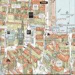
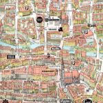
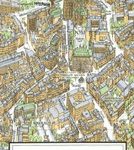
Berlin Street Plan & Panorama Map
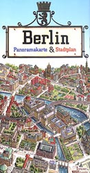
Berlin from Terra Nostra on a double-sided map combining a conventional street plan of the city’s central districts, highlighting numerous sights, with a beautifully drawn 3-D panorama map of the centre presenting all the buildings drawn with full architectural detail.On one side is a conventional street plan of Berlin’s central districts extending from the Olympic Stadium in the west across Charlottenburg and the centre of the old West Berlin to the present-day city centre around Unter der Linden and beyond it to Friedrichshain, Locations of interesting landmarks, from famous sights such as the Reichstag or the TV tower to local churches, are highlighted by small drawings. The map also shows the course of the Berlin Wall. U- and S-Bahn stations and lines are prominently marked, as are the 100 and 200m bus routes. The plan also shows one way streets, car parks, various facilities and locations of selected embassies and consulates. Map legend includes English.On the reverse is a speciality of the Terra Nostra publishers and their artist Ruben Atoyan: a beautiful panorama map of the city centre with all the buildings drawn in 3-D with full architectural detail. 185 sights are numbered and listed under the map with their German and English names. Separate insets show in greater detail the centre of the old West Berlin around the Kurfรผrstendamm and the Museum Island.

Related Products:
 Krakow City Centre and Panorama TerraNostra Map
 Zurich Panorama Plan
 Vilnius Briedis Street Plan and Panorama
 Munich in 3-D Street Plan
 Hamburg in 3-D Street Plan
 Hanover in 3-D Street Plan
 Lรผbeck in 3-D Street Plan
 Cologne in 3-D Street Plan
 Stuttgart in 3-D Street Plan
 Nuremburg in 3-D Street Plan
 Dusseldorf in 3-D Street Plan
 Aachen in 3-D Street Plan
 Gdansk Panorama Plan
 Rothenburg ob der Tauber in 3-D Street Plan
 Vienna F&B Tourist Street Plan
 Basel Pocket Street Plan
 Bamberg in 3-D Street Plan
 Trier in 3-D Street Plan
 Santiago de Chile Trekkingchile Street Plan
 Frankfurt am Main Bird`s Eye View Street Plan
 Bratislava Street Plan
 Trieste Global Map Street Plan
 Kiev Kartografija Street Plan
 Innsbruck F&B Tourist Street Plan
 Kaunas Jana Seta Street Plan
 Linz F&B Tourist Street Plan
 Tartu Jana Seta Street Plan WATERPROOF
 Jurmala Jana Seta Street Plan
 Skopje Panoramic Street Plan
 Pรคrnu Jana Seta Street Plan WATERPROOF
 Siena Global Map Street Plan
 Verona Global Map Street Plan
 Bishkek Street Plan
 Barcelona: Modernisme Architecture Street Plan
 Padua Global Map Street Plan
 Cagliari Global Map Street Plan
 Barcelona: Romanesque and Gothic Architecture Street Plan
 Pisa Street Plan
 Catania Global Map Street Plan
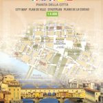 Florence Global Map Street Plan