Disclosure : This site contains affiliate links to products. We may receive a commission for purchases made through these links.
Berlin Marco Polo City Map
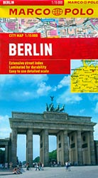
Berlin on a pocket-size street plan from Marco Polo Travel Publishing printed on sturdy, waterproof and tear-resistant synthetic paper, with tram and bus routes shown with stops and line numbers, U- and S-Bahn stations clearly marked and the lines shown on a separate diagram, lists of useful addresses, etcThe plan is at 1:15,000 and covers the city with its suburbs, extending north-west to include the Tegel airport, south to the grounds of the old Tempelhof airport, west to include the Messe grounds, and east to the Frankfurter Tor station.The plan shows tram and bus routes with stops and line numbers, U/S-Bahn stations, one way streets, car parks and pedestrianized areas. Important buildings and places of interest are marked. Cartography is from the renowned German publishers MairDumont. Multilingual map legend includes English.The index is on the reverse side and includes extensive lists of useful contact details for tourist information offices, hotel reservation, campsites and youth hostels, car hire, museums, emergency services, etc. Also provided is a very clear diagram of the U/S-Bahn and rail network, plus a road map of the city’s environs.

Related Products:
 Warsaw Marco Polo City Map
 Budapest Marco Polo City Map
 Prague Marco Polo City Map
 Brussels Marco Polo City Map
 Bangkok Marco Polo City Map
 Berlin Falk Touristplan Pocket Map
 Florence Marco Polo City Map
 Istanbul Marco Polo City Map
 Boston Marco Polo City Map
 St Petersburg Marco Polo City Map
 Berlin Cityplan Pocket Map
 Helsinki City Map
 Rio de Janeiro Marco Polo City Map
 Munich F&B
 Hong Kong Marco Polo City Map
 Munich F&B Wall Map
 Cape Town Marco Polo City Map
 Berlin Michelin City Map
 Berlin ADAC CityAtlas
 Frankfurt Marco Polo City Map
 Munich F&B Wall Map – with Metal Hanging Strips
 Berlin Borch
 Munich & Bavaria ITMB
 Berlin Michelin Citymap
 Innsbruck City Map
 Hamburg Marco Polo City Map
 Riga City Center Jana Seta Street Plan
 Munich Marco Polo City Map
 Salzburg F&B Street Plan
 Nuremberg City Pocket Plan
Munich EXTRA
Nuremberg City Pocket Plan
Munich EXTRA
 Kaunas Jana Seta Street Plan WATERPROOF
 Jurmala Jana Seta Street Plan
 Zurich & Switzerland NW ITMB
 Budapest City Plan
 Warsaw & Poland East ITMB
 Ljubljana
 Vancouver & Greater Vancouver ITMB
 Bavaria South Marco Polo Regional Map 13
 Amsterdam Michelin City Map