Disclosure : This site contains affiliate links to products. We may receive a commission for purchases made through these links.
Berlin Cityplan Pocket Map
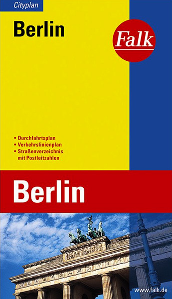
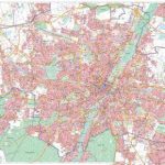
Pocket size “Cityplan” map of Berlin from Falk with coverage of the city’s outer districts including access to the Tegel Airport, plus an enlargement for the city centre, a street plan of Potsdam, a diagram of the U & S-Bahn network, and a road map of the city with its outer suburbs.The main plan extends from the Berlin Tegel Airport to the Klein-Machnow and Marienfelde districts in the south and east beyond Friedrichshain. The plan is drawn in a special Falk presentation ‘“ its scale changes from 1:25,000 in the centre to 1:32,000 along the edges of the map, with a 1km grid to indicate distances. In addition to the U-Bahn and S-Bahn lines, tram and bus lines are shown with stops and line numbers. Streets are annotated with selected house numbers for easier identification of addresses. Central Berlin, from Charlottenburg across the Tiergarten to Alexander Platz is shown in greater detail on two panels at 1:15,000. Included with the plans is a road map at 1:100,000 showing main traffic arteries, S-Bahn lines and P+R facilities. On the reverse is the index, a diagram of the U- and S-Bahn network, plus a street plan of Potsdam including the park of the Sanssouci Palace. Map legend includes English.

Related Products:
 Berlin Falk Touristplan Pocket Map
 Bonn Falk Pocket Cityplan
 Berlin Michelin City Map
 Augsburg Falk Cityplan
 Hanover Falk Cityplan
Dresden Falk Cityplan
Hanover Falk Cityplan
Dresden Falk Cityplan
 Nuremberg City Pocket Plan
Munich Falk Cityplan
Nuremberg City Pocket Plan
Munich Falk Cityplan
 Berlin Marco Polo City Map
 Berlin Borch
 Kiel City Pocket Plan
 Lubeck City Pocket Plan
 Munster City Pocket Plan
 Potsdam City Pocket Plan
 Bremen City Pocket Plan
 Dortmund City Pocket Plan
 Munich F&B
 Berlin F&B City Pocket Map
 Basel Pocket Street Plan
 Munich F&B Wall Map
 Dresden City Pocket Plan
 Hamburg City Pocket Plan
 Cologne City Pocket Plan
 Stuttgart City Pocket Plan
 Leipzig City Pocket Plan
 Dรผsseldorf City Pocket Plan
 Munich F&B Wall Map – with Metal Hanging Strips
Nuremberg Falk EXTRA Street Plan
Munich F&B Wall Map – with Metal Hanging Strips
Nuremberg Falk EXTRA Street Plan
 Berlin ADAC CityAtlas
 Berlin Michelin Citymap
 Frankfurt City Pocket Map
Munich EXTRA
Berlin EXTRA
Wรผrzburg Falk Cityplan
Bremerhaven Falk Cityplan
Koblenz Falk Cityplan
Regensburg Falk Cityplan
Osnabrรผck Falk Cityplan
Halle (Saale) Falk Cityplan
Frankfurt City Pocket Map
Munich EXTRA
Berlin EXTRA
Wรผrzburg Falk Cityplan
Bremerhaven Falk Cityplan
Koblenz Falk Cityplan
Regensburg Falk Cityplan
Osnabrรผck Falk Cityplan
Halle (Saale) Falk Cityplan