Disclosure : This site contains affiliate links to products. We may receive a commission for purchases made through these links.
Bergueda: Berga – Serra del Cadรญ Ed. Alpina Paragliding Map
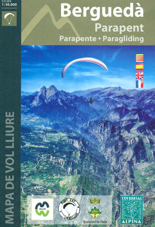
The Berga – Serra del Cadรญ area of the Catalan Pyrenees presented by Editorial Alpina at 1:50,000 on a contoured and GPS compatible map highlighting sites for paragliding, annotated with information about takeoff cross or hike-&-fly, thermals and wind direction, minimal altitude, GPS waypoints, etc.The base map has contours at 20m intervals with relief shading and numerous spot heights. Paragliding sites are prominently highlighted and annotated with the relevant details. Eight cross sites and 10 hike-&-fly locations are also listed in tables under the map with their GPS waypoints. An overprint also highlights local and long-distance hiking paths and an extensive range of symbols indicate various facilities and places of interest, including accommodation (campsites, youth hostels, mountain refuges, farms, etc), sport and recreational sites, car parks and petrol stations, interesting trees and botanical gardens, etc. In addition to the waypoint for the paragliding sites, the map has a 5km UTM grid. Map legend and other information include English.

Related Products:
 Serra del Cadรญ – Pedraforca Editorial Alpina
 Montgrony – Fonts del Llogregat – Parc Natural del Cadรญ-Moixerรฒ Editorial Alpina
 Delta of the Ebro ‘“ Serra de Montsiร Editorial Alpina
 Moixerรณ – La Tosa – Cadรญ-Moixerรณ Natural Park Editorial Alpina
 Rasos de Peguera – Serra d`Ensija Editorial Alpina
 Muntanya d’Alinyร Editorial Alpina
 Serra de Tramuntana Editorial Alpina 4-Map Set
 Ordesa and Monte Perdido National Park Editorial Alpina
 Taga – Serra Cavallera Editorial Alpina
 Paragliding Annapurna
 Ripollรจs Editorial Alpina
 La Senda de Camille Editorial Alpina
 Ordesa and Monte Perdido National Park 2-Map Set Editorial Alpina
 Ordesa – Monte Perdido National Park Editorial Alpina 2-Map Set
 Serra de Pร ndols and Serra de Cavalls
 Macizo de Monte Perdido – Valle de Ordesa – Pineta Editorial Alpina
 Cavalls del Vent – Cadi-Moixero Natural Park Hiking Circuit Editorial Alpina
 Valles de Belagua y Roncal Editorial Alpina
 Posets-Maladeta Natural Park 2-Map Set Editorial Alpina
 Valles de Irati y Aezkoa Editorial Alpina
 Catllarร s – Picancel Editorial Alpina
 Cadรญ-Moixerรณ Natural Park East: el Moixerรณ – Tรบnel del Cadรญ
Cerdanya – Alta Cerdanya – Capcir – Andorra Editorial Alpina
Cadรญ-Moixerรณ Natural Park East: el Moixerรณ – Tรบnel del Cadรญ
Cerdanya – Alta Cerdanya – Capcir – Andorra Editorial Alpina
 Mallorca – Tramuntana South Editorial Alpina
 Travessa 3 Refugis – Caranรงร – Ulldeter – Coma de Vaca Editorial Alpina
 Mallorca – Tramuntana Central Editorial Alpina
 Congost de Mont-rebei Editorial Alpina
 Valle de Benasque Editorial Alpina
 Marina Baixa – Serra d`Aitana Editorial Piolet
 Serra de Bernia – Marina Alta Editorial Piolet
 Serra de Llaberia Editorial Piolet
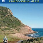 Menorca – Camรญ de Cavalls – GR223 Editorial Alpina CATALAN
 Mallorca – Tramuntana North Editorial Alpina
Garraf – la Morella – Eramprunya Editorial Alpina
Serra de Boumort – 2-Map Set
Mallorca – Tramuntana North Editorial Alpina
Garraf – la Morella – Eramprunya Editorial Alpina
Serra de Boumort – 2-Map Set
 Serra de Miramar
Bachimala – Valles de Chistau y Bielsa Editorial Alpina
Valles de Ansรณ & Echo Editorial Alpina
Serra de Miramar
Bachimala – Valles de Chistau y Bielsa Editorial Alpina
Valles de Ansรณ & Echo Editorial Alpina
 Cabo de Gata-Nรญjar Natural Park Editorial Alpina
Sierra Nevada – La Alpujarra Editorial Alpina
Cabo de Gata-Nรญjar Natural Park Editorial Alpina
Sierra Nevada – La Alpujarra Editorial Alpina