Disclosure : This site contains affiliate links to products. We may receive a commission for purchases made through these links.
Benelux F&B
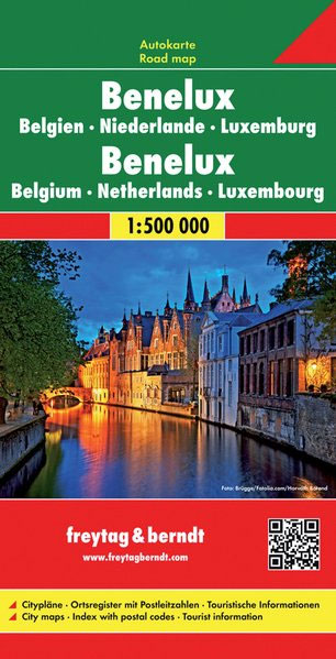
Benelux road map at 1:500,000 from Freytag & Berndt with good coverage of the Eifel and the Rhine Valley in Germany. The index booklet attached to the map cover has street plans of central Amsterdam, The Hague, Brussels and Luxembourg City.Road network is graded into six different types of roads, with driving distances shown on most routes and motorway services clearly marked. Scenic routes are highlighted. The map also shows railway network, local airports, and both internal and international ferry services. Small symbols indicate various places of interest. National parks are highlighted. Latitude and longitude lines are drawn at 30` intervals. Map legend includes English.

Related Products:
 Benelux – North France Michelin Road Atlas SPIRAL-BOUND
 Benelux Michelin
 Germany – Benelux – Austria – Czechia Michelin
 Benelux: Michelin Regional Road Maps and Atlases
 Thailand F&B
 Tajikistan – The Pamirs Gizi Map
 Montenegro F&B
 Germany K+F Road Map
Brittany – Brest – Rennes K+F Regional Road Map
Benelux Falkplan Routiq Road Atlas
Germany K+F Road Map
Brittany – Brest – Rennes K+F Regional Road Map
Benelux Falkplan Routiq Road Atlas
 Uzbekistan Gizi Map
 Tajikistan – The Pamirs Gizi Map Wall Map
 Germany South K+F Road Map
 Uzbekistan Gizi Map Wall Map
 Albania F&B Top 10 Tips
 Belarus Jana Seta Road Map
 Quito & Central Ecuador ITMB
 Benelux Motorhome Stopovers Trailer`s Park Road Map
 Myanmar / Burma F&B
 Denmark South – Kolding – Copenhagen – Bornholm K+F Regional Road Map
 Colombia F&B
 Belgium North & Centre Michelin Regional 533
 Scandinavia & Finland Michelin
 Bosnia-Herzegovina – Montenegro Reise Know-How
 South Jutland and Funen – Esbjerg – Odense
 Azores F&B
 Poland North
 Poland South
 Istanbul & Northwest Turkey ITMB
 Belgium South Michelin Regional 534
 Argentina South & Tierra del Fuego ITMB
 Netherlands North Michelin Regional 531
 Netherlands South Michelin Regional 532
 USA North-East
 Portugal F&B
Italy F&B Great Road Atlas SPIRAL-BOUND
Portugal F&B
Italy F&B Great Road Atlas SPIRAL-BOUND
 Italy North K+F Road Map
 Italy K+F Double-Sided Road Map
 Germany – Benelux – Austria – Switzerland – Czech Republic Michelin Tourist and Motoring Atlas 2021
 Italy: Touring Club Italiano 200K Regional Road Maps