Disclosure : This site contains affiliate links to products. We may receive a commission for purchases made through these links.
Belize NGS Adventure Map 3106
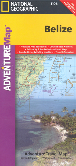
Belize Adventure Map at 1:400,000 from the National Geographic Society, printed on light waterproof and tear-resistant plastic paper, with street plans of central Belize City and San Pedro, site map of Tikal, and additional tourist information.On one side is a map of Belize at 1:400,000 designed to highlight the country’s protected areas: national parks, wildlife sanctuaries, forest, mangrove or marine reserves, etc. Coverage extends to the border areas of Guatemala including the Tikal National Park and its archaeological sites. The map has contours at 50m intervals enhanced by relief shading and colouring/graphics showing the forest cover, swamps and coral reefs in coastal waters.Numerous protected areas are highlighted, with the colouring of their boundaries indicating their official status. Road network distinguishes between paved, gravel and dirt roads and shows border crossings and petrol stations. Local airports and ferry routes are marked. A range of symbols highlight various places of interest including Maya sites, beaches, windsurfing and snorkel ling places, diving and fishing sites, etc. The map has both UTM grid and latitude/longitude margin ticks at intervals of 15’. There is no index of localities but the map includes a list of all the protected areas from national parks to private reserves. On the reverse are street plans of central Belize City and San Pedro highlighting main sights, accommodation and other tourist facilities, plus a detailed site plan of the Maya ruins at Tikal. Also provided is advice for travellers to Belize and descriptions of the country’s various regions illustrated with colour photos.

Related Products:
 Belize & Eastern Guatemala ITMB
 Belize Borch
 Guatemala – Belize Reise Know-How
 The Rough Guide to Belize: with Tikal and Flores
 Belize Dive Map
 Insight Guides Guatemala, Belize and Yucatan
 Lonely Planet Belize
 Yucatan Borch
 Mexico Road Map
 Northern Yucatan Peninsula NGS Adventure Map 3105
 Guatemala NGS Adventure Map 3110
 Time Among the Maya: Travels in Belize, Guatemala and Mexico
 Mexico NGS Adventure Map 3108
 Puerto Rico NGS Adventure Map 3107
 Thailand Adventure Map
 South Africa Adventure Map
 Southern Baja California NGS Adventure Map 3104
 Peru NGS Adventure Map 3404
 Yucatan and the Mayan Region – Belize Micheling Zoom 185
 Slovenia Adventure Map
 Dominican Republic NGS Adventure Map 3102
 Hawaii NGS Adventure Map 3111
 Khumbu NGS Adventure Map 3002
 Chile NGS Adventure Map 3402
 Cuba NGS Adventure Map 3112
 Egypt NGS Adventure Map 3202
 Panama NGS Adventure Map 3101
 Northern Baja California NGS Adventure Map 3103
 Malawi Map Studio Adventure Map
 Botswana Map Studio Adventure Map
 Tuscany Adventure Map
 Langtang NGS Adventure Map 3004
 Sicily NGS Adventure Map 3310
 Vietnam North NGS Adventure Map 3015
 Vietnam South NGS Adventure Map 3016
 Mexico Nelles
 Insight Guides Belize (Travel Guide with Free eBook)
 Nicaragua – Honduras – El Salvador NGS Adventure Map 3109
 Argentina NGS Adventure Map 3400
 National Three Peaks Adventure Atlas: Ben Nevis, Scafell Pike, Snowdon