Disclosure : This site contains affiliate links to products. We may receive a commission for purchases made through these links.
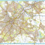
Belfast OSNI Street Plan

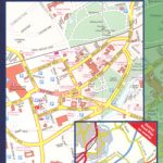
Belfast at 1:12,000 on a large double-sided street plan from the Ordnance Survey of Northern Ireland, with a separate index booklet and information which includes one way streets, National Cycle Network cycle paths, etc.Coverage extends east to include Dundonald and Ballybeen shown as an inset. The map highlights main traffic arteries across the city and shows one way streets and car parks. Railway lines are shown with station names. Public buildings are highlighted and named. The map shows Sustrans National Cycle Network cycle paths, tow paths and waymarked walking trails. Local administrative boundaries are marked and the map also has 1-km Irish national grid lines. Street index is in a separate booklet attached to the map cover. Current edition of this map was published in 2013.

Related Products:
 Lisburn City OSNI Street Plan
 Armagh City OSNI Street Plan
 Belfast OSNI Discovery 15
 Leeds A-Z Street Plan Wall Map
 Moscow Jana Seta Street Plan
 Salzburg F&B Street Plan
 Liverpool A-Z Street Plan Wall Map
 Sheffield A-Z Street Plan Wall Map
 Nuremberg Falk EXTRA Street Plan
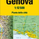 Genoa TCI Street Plan
 Plymouth A-Z Street Plan Wall Map
 Salzburg F&B Tourist Street Plan
 Leicester A-Z Street Plan Wall Map
Warsaw – Lomianki – Zabki ExpressMap Street Plan
Leicester A-Z Street Plan Wall Map
Warsaw – Lomianki – Zabki ExpressMap Street Plan
 Rome Global Map Street Plan
 Reims IGN Street Map
 Jurmala Jana Seta Street Plan
 Venice TCI Street Plan
 Constanta Cartographia Street Plan
 Amsterdam Falkplan Street Plan
 Dakar Laure Kane Street Plan
 Bangkok Walks Street Plan
Amsterdam Falkplan Street Plan and Cycling Map
Bangkok Walks Street Plan
Amsterdam Falkplan Street Plan and Cycling Map
 Northern Ireland: OSNI 50K Discoverer Maps
Lodz ExpressMap Street Plan
Northern Ireland: OSNI 50K Discoverer Maps
Lodz ExpressMap Street Plan
 Poznan ExpressMap Street Plan
 Wroclaw ExpressMap Street Plan
 Avignon IGN Street Map
Bremen Falk EXTRA Street Plan
Hanover Falk EXTRA Street Plan
Avignon IGN Street Map
Bremen Falk EXTRA Street Plan
Hanover Falk EXTRA Street Plan
 Pau Blay-Foldex Street Plan
 Krakรณw – Niepolomice – Skawina – Wieliczka ExpressMap Street Plan
Trier Falk EXTRA Street Plan
Krakรณw – Niepolomice – Skawina – Wieliczka ExpressMap Street Plan
Trier Falk EXTRA Street Plan
 Turin TCI Street Plan
 Bastia – Ajaccio – Calvi – Porto Vecchio Blay-Foldex Street Plan
 Hyรจres Blay-Foldex Street Plan
 Mรขcon Blay-Foldex Street Plan
 Riga City Center Jana Seta Street Plan
Frankfurt am Main Falk EXTRA Street Plan
Riga City Center Jana Seta Street Plan
Frankfurt am Main Falk EXTRA Street Plan
 Nimes Blay-Foldex Street Plan