Disclosure : This site contains affiliate links to products. We may receive a commission for purchases made through these links.
Beijing & the Great Wall ITMB
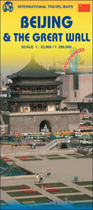
Beijing on a light, waterproof and tear-resistant map combining a street plan of the city at 1:23,000 with, on the reverse, a road map of its environs clearly showing the existing parts of the Great Wall and its entire course, plus numerous other historical and recreational sites.On one side is a very clear, easy to read street plan of the capital at 1:23,000. Metro, railway and bus stations and ferry terminals are prominently marked and main traffic arteries are indicated. Numerous places of interest to visitors are highlighted, including selected hotels, cultural institutions and historical sites, shopping centres, etc, – most shown with their names. Also provided are an enlargement of the Forbidden City and a diagram of Beijing’s metro network.On the reverse is a road map at 1:280,000 of the surrounding region prominently highlighting the course of the Great Wall of China, indicating the remaining sections and the missing ones. Also marked are numerous other sights, including temples, museums, tombs, scenic areas and recreational sites, etc. The map has no geographical coordinates.Both the plan and the road map show all place names in the Latin alphabet only and both are indexed.

Related Products:
 Beijing Borch
 Rome & Southern Italy ITMB
 Sao Paulo & Brazil South Coast ITMB
 Tehran & Northern Iran ITMB
 Helsinki & Southern Finland ITMB
 Bangkok & Thailand South ITMB
 Moscow ITMB
 Cairo & Nile Delta ITMB
 Warsaw & Poland East ITMB
 Shanghai & China South East ITMB
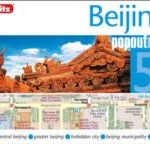 Beijing Popout Map
 Istanbul & Northwest Turkey ITMB
 DK Eyewitness Top 10 Beijing
 Easter Island & Santiago ITMB
 Kuwait & Kuwait City ITMB
 Stockholm & Southern Sweden ITMB
 Osaka & Western Japan ITMB
 Manila ITMB
 Hungary & Budapest ITMB
 Tokyo & Central Japan ITMB
 Turkmenistan Gizi Wall Map
 Iran & Tehran ITMB
 An Armchair Traveller`s History of Beijing
 Munich & Bavaria ITMB
 Oslo / Bergen & South of Norway ITMB
 Taiwan & Taipei ITMB
 Red Sea Wall Map
 Singapore & Malay Peninsula ITMB
 Cuba Wall Map
 India North East & Kolkata / Calcutta ITMB
 Great Britain: The Daily Telegraph Wall Map of Great Britain & Ireland
 Santiago & Chile North ITMB
 Czech Republic ITMB
 Las Vegas ITMB
 Krakow ITMB
 Kyoto & Japan West ITMB
 The Great Wall of China
 Jerusalem & Holy Land ITMB
 Great Britain: The Daily Telegraph Wall Map of Great Britain & Ireland (ENCAPSULATED)
 Tel Aviv-Jaffa & Central Israel ITMB