Disclosure : This site contains affiliate links to products. We may receive a commission for purchases made through these links.
Barnet and Hadley 1896
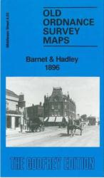
Barnet and Hadley in 1896 in a fascinating series of reproductions of old Ordnance Survey plans in the Alan Godfrey Editions, ideal for anyone interested in the history of their neighbourhood or family. The map shows parts of two communities, Chipping Barnet and Monken Hadley. Coverage extends from Wood Street, in Chipping Barnet, northward along the High Street – or Great North Road – to Hadley Green. Just north of this, at the top of the map, is the site of the Battle of Barnet 1471. The map extends west to Galley Lane, the boundary with Hertfordshire. Features on the map include Hadley Brewery, Hadley House, Old Windmill pub, Old Fold Manor Farm, Militia Barracks, Christ Church. On the reverse are street directories for Hadley Green, Hadley High Stone, Barnet High Street, Puller Road, Salisbury Road, Sebright Road, Stapylton Road, Union Street and Wood Street.About the Alan Godfrey Editions of the 25″ OS Series:Selected towns in Great Britain and Ireland are covered by maps showing the extent of urban development in the last decades of the 19th and early 20th century. The plans have been taken from the Ordnance Survey mapping and reprinted at about 15 inches to one mile (1:4,340). On the reverse most maps have historical notes and many also include extracts from contemporary directories. Most maps cover about one mile (1.6kms) north/south, one and a half miles (2.4kms) across; adjoining sheets can be combined to provide wider coverage.FOR MORE INFORMATION AND A COMPLETE LIST OF ALL AVAILABLE TITLES PLEASE CLICK ON THE SERIES LINK.

Related Products:
 Monken Hadley 1896
 New Barnet 1896
Friern Barnet and New Southgate 1898
East Barnet & Southgate 1897 – 7.09
Norton 1896
Chipping Ongar 1915
North London 1902-13 – 256
New Barnet 1896
Friern Barnet and New Southgate 1898
East Barnet & Southgate 1897 – 7.09
Norton 1896
Chipping Ongar 1915
North London 1902-13 – 256
 Hamilton 1896
Old Portsmouth & Gosport 1896 – 83.11a
Wood Green 1912 – 7.3
Hamilton 1896
Old Portsmouth & Gosport 1896 – 83.11a
Wood Green 1912 – 7.3
 Wood Green 1894 – 7.2
Southsea 1896 – 83.12a
Wood Green 1894 – 7.2
Southsea 1896 – 83.12a
 Wood Green 1935 – 7.4
Motherwell 1896
Stranton & Southern Hartlepool 1896 – 37.15
Wood Green 1935 – 7.4
Motherwell 1896
Stranton & Southern Hartlepool 1896 – 37.15
 Poynton West 1896
Wishaw 1896
Glasgow High Street 1909
Glasgow High Street 1933
Darlington North 1896
Tettenhall 1900
Poynton West 1896
Wishaw 1896
Glasgow High Street 1909
Glasgow High Street 1933
Darlington North 1896
Tettenhall 1900
 Watford South and New Bushey 1896
Lanark 1896 – 25.15
Easington Lane and Bryn Gates 1896
Bishop Middleham & Mainsforth Hall 1896 – 35.15
Watford South and New Bushey 1896
Lanark 1896 – 25.15
Easington Lane and Bryn Gates 1896
Bishop Middleham & Mainsforth Hall 1896 – 35.15
 Hexham 1896
 Winchmore Hill 1896 – 7.10a
 Lewisham 1914 – 119.3
Holmside and Edmondsley 1896
Brightlingsea 1895
Lewisham 1914 – 119.3
Holmside and Edmondsley 1896
Brightlingsea 1895
 Mid Finchley 1934
 Mid Finchley 1911
 Lewisham 1863-67 – 119.1
Washington 1896
Lewisham 1863-67 – 119.1
Washington 1896
 Sevenoaks North and Riverhead 1907
Kirkintilloch 1896
North Calder & Douglas Support 1896 – 11.04
Sevenoaks North and Riverhead 1907
Kirkintilloch 1896
North Calder & Douglas Support 1896 – 11.04
 North London Three Borough Challenge Walk – Enfield, Barnet and Haringey
Crook East 1896
North London Three Borough Challenge Walk – Enfield, Barnet and Haringey
Crook East 1896
 New Hartley and Delaval Hall 1896