Disclosure : This site contains affiliate links to products. We may receive a commission for purchases made through these links.
Barcelona Province
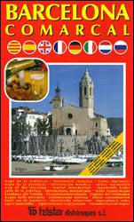
Barcelona Province on an indexed road map at 1:200,000 from Telstar with colouring indicating its administrative subdivisions, plus English language descriptions of 10 tourist routes in various parts of the province.The map shows the province’s road network on a base with colouring indicating the subdivision into Comarcal administrative units, emphasizing motorways and main roads. Symbols highlight various places of interest including World Heritage sites, paradors, etc. Topography is indicated my names of main peaks. The map has no geographical coordinates. The index is next to the map. Map legend includes English.On the reverse are multilingual descriptions of the region’s 10 best sightseeing routes, accompanied by a small map of the province highlighting these routes.

Related Products:
 Barcelona Province 200K CNIG Map No. 9
 China Gizi Map Geographical Wall Map
 Murcia
 China Administrative Wall Map
 Quรฉbec Province FastTrack
 Jaรฉn Province 200K CNIG Map No. 23
 Cadรญz Province 200K CNIG Map No. 12
 Leรณn Province 200K CNIG Map No. 27
 Mรกlaga Province 200K CNIG Map No. 31
 Cรกceres Province 200K CNIG Map Np. 11
 Cรณrdoba Province 200K CNIG Map No. 16
 A Coruรฑa Province 200K CNIG Map No. 24
 La Rioja Province 200K CNIG Map No. 25
 Ourense Province 200K CNIG Map No. 34
 Teruel Province 200K CNIG Map No. 43
 Cuenca Province 200K CNIG Map No. 17
 Salamanca Province 200K CNIG Map No. 37
 Almeria Province 200K CNIG Map No. 4
 Madrid Province 200K CNIG Map No. 30
 Murcia Province 200K CNIG Map No. 32
 Cantabria Province 200K CNIG Map No. 13
Avila Province 200K CNIG Map No. 6
Cantabria Province 200K CNIG Map No. 13
Avila Province 200K CNIG Map No. 6
 Valencia Province 200K CNIG Map No. 45
Alicante Province 200K CNIG Map No. 3
Valencia Province 200K CNIG Map No. 45
Alicante Province 200K CNIG Map No. 3
 Las Palmas Province 200K CNIG Map No. 26
 Lugo Province 200K CNIG Map No. 29
 Soria Province 200K CNIG Map No. 41
 Badajoz Province 200K CNIG Map No. 7
 Huelva Province 200K CNIG Map No. 21
 Seville Province 200K CNIG Map No. 40
 Pontevedra Province 200K CNIG Map No. 36
 Huesca Province 200K CNIG Map No. 22
 Lleida Province CNIG 200K Map No. 28
 Granada Province 200K CNIG Map No. 19
 Asturias Province 200K CNIG Map No. 5
 Tarragona Province 200K CNIG Map No. 42
 Toledo Province 200K CNIG Map No. 44
 Girona Province 200K CNIG Map No. 18
Cรกceres
Girona Province 200K CNIG Map No. 18
Cรกceres
 Castellรณn / Castello Province 200K CNIG Map 14