Disclosure : This site contains affiliate links to products. We may receive a commission for purchases made through these links.
Barcelona: Greater Barcenona Telstar Street Atlas
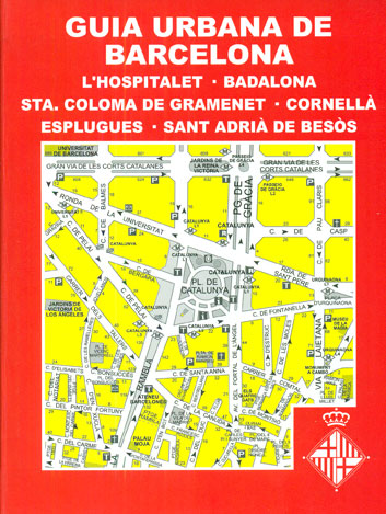
Greater Barcelona area on a handy size, 2cm thick street atlas from the locally-based publishers Telstar Distrimapas, with streets annotated with selected house numbers and the direction of traffic, an extensive index showing street names with their postcodes, etc. Coverage includes L’Hospitalet de Llobregat, Badalona, Santa Coloma de Gramenet, Cornellร de Llobregat, Esplugues de Llobregat and Sant Adriร de Besรฒs, which each of these locations presented on a separate set of indexed plans.Important buildings are named, metro stations and taxi ranks are clearly marked, and symbols indicate various facilities including petrol stations and car parks, tourist information offices, etc. The index section includes a list of foreign consulates, a list of other locations within Catalonia with distances from Barcelona, plus a list of selected Barcelona’s streets with ‘numbering at the junction with other streets at the level of the first property in each block”. Map legend includes English. Unfortunately no scale is given for the mapping.PLEASE NOTE: the atlas covers the 154 pages indicated on our coverage image, plus the remaining area around them shown in yellow.
Related Products:
 Greater Manchester A-Z Street Atlas
 Barcelona “Maps to Go” Street Plan
 Sofia Street Atlas with Vitosha Massif
 Skopje Street Atlas
 Prague Street Atlas
 Helsinki Region Street Atlas
 Greater Vienna F&B Street Atlas
 Norwich A-Z Street Atlas
 Birmingham A-Z Street Atlas
 Valencia Pocket Street Atlas
 Greater London A-Z Master Atlas
 Vancouver Greater and Fraser Valley Street Atlas Deluxe Edition
 Greater London Collins Street Atlas
 Newcastle upon Tyne A-Z Street Atlas
 Manchester A-Z Street Atlas
 Manhattan Block-by-Block Street Atlas
 Mumbai (Bombay) Street Atlas
 Pune City Street Atlas
 Kolkata / Calcutta Street Atlas
 Navi Mumbai Street Atlas
 Greater Oslo Cappelen Street Plan
 Barcelona: Gaudรญ Architecture Street Plan
 Barcelona High 5 Edition Street Plan
 Liverpool A-Z Street Atlas
 Zurich Pocket Street Atlas
 Chennai / Madras Street Atlas
 Manchester A-Z Big Street Atlas SPIRAL-BOUND
 Nottingham – Ilkeston – Long Eaton – West Bridgford A-Z Street Atlas
 Barcelona: Romanesque and Gothic Architecture Street Plan
 Merseyside A-Z Street Atlas
 Aberdeen A-Z Street Atlas
 Zurich Street Atlas
 Delhi Street Atlas
 Taunton A-Z Street Atlas
 Nottinghamshire A-Z County Street Atlas
 Wirral – Birkenhead – Ellesmere Port – Wallasey A-Z Street Atlas
 Bristol – Bath A-Z Street Atlas
 Barcelona: Modernisme Architecture Street Plan
 Isle of Wight A-Z Street Atlas
 Dartford – Gravesend A-Z Street Atlas


