Disclosure : This site contains affiliate links to products. We may receive a commission for purchases made through these links.
Bangkok and the Nearby Provinces
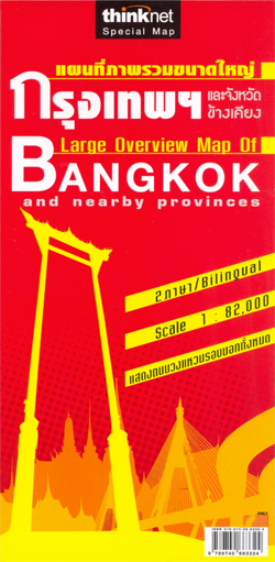
Bangkok with its outer suburbs and the surrounding area at 1:82,000 on a road map from the locally based publishers Thinknet. All place names, including sights and facilities highlighted on the map, are in both Thai and Latin alphabet.The map presents the area’s road network in detail, highlighting main routes and clearly showing the interchanges. Railway lines are shown with stations. Boundaries of local administrative units are marked with their names in large, clearly legible print. The plan indicates numerous public buildings, services or facilities and places of interest, all conveniently colour-coded but with their names in very small size print.

Related Products:
 Chiang Mai and Nearby Provinces
 Phuket and the Nearby Provinces: Krabi, Trang, Phangnga
 Bangkok and Greater Bangkok Nelles
 Bangkok & Thailand South ITMB
 Bangkok Borch
 Bangkok Handy Atlas
 Central and Eastern Thailand
 Northern Thailand
 Bangkok Marco Polo City Map
 North-Eastern Thailand
 Pattaya – Ko Chang: Chonburi, Rayong, Chanthaburi, Trat
 Jordan
 Togo & Benin ITMB
 Southern Thailand
 Cordillera Cantabrica – Asturias and the Surrounding Provinces Adrados Map
 Algeria F&B
 Thailand Handy Road Atlas
 Bosnia-Herzegovina – Montenegro Reise Know-How
 Myanmar / Burma F&B
 Bangkok Walks Street Plan
 Mali & Mauritania ITMB
 Kiev Administrative Region
Zaporizhzhia Administrative Region
Zhytomyr Administrative Region
Ternopil Administrative Region
Khmelnytskyi Administrative Region
Lviv Administrative Region
Dnipropetrovsk Administrative Region
Mikolayiv Administrative Region
Rivne Administrative Region
Vinnytsia Administrative Region
Chernihiv Administrative Region
Kharkiv Administrative Region
Cherkasy Administrative Region
Poltava Administrative Region
Kirovohrad Administrative Region
Kherson Administrative Region
Chernivtsi Administrative Region
Sumy Administrative Region
Kiev Administrative Region
Zaporizhzhia Administrative Region
Zhytomyr Administrative Region
Ternopil Administrative Region
Khmelnytskyi Administrative Region
Lviv Administrative Region
Dnipropetrovsk Administrative Region
Mikolayiv Administrative Region
Rivne Administrative Region
Vinnytsia Administrative Region
Chernihiv Administrative Region
Kharkiv Administrative Region
Cherkasy Administrative Region
Poltava Administrative Region
Kirovohrad Administrative Region
Kherson Administrative Region
Chernivtsi Administrative Region
Sumy Administrative Region
 Tibet Reise Know-How