Disclosure : This site contains affiliate links to products. We may receive a commission for purchases made through these links.
Baden-Wรผrttemberg Official Road Map
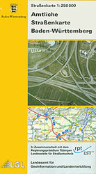
German state of Baden-Wรผrttemberg at 1:250,000 on a GPS compatible road map from its survey organization, showing the road network with its official numbers at all levels, railways, airports and internal administrative divisions.The map presents the state’s road network in colours indicating the official classification and all the sections, as appropriate, show their official road numbers. Small, unnumbered country roads are included. On autobahns distances are marked at 10km intervals, various facilities are marked and interchanges are shown with both their numbers and their names.Railway lines are shown with station and stops. The map also indicates locations of airports, aerodromes and helicopter landing pads. Three levels of internal administrative boundaries are also marked. The map has no contours or relief shading to indicate topography, just colouring showing forested areas. The state’s various protected areas are not marked. Latitude and longitude lines are at 6’ and 10’ respectively to correspond to the German national grid. The numbering in the margin enables the users to work sheet numbers for the 1:25,000 standard topographic mapping of the state. The map is not indexed. Map legend is in German only.

Related Products:
 Baden-Wรผrttemberg – Black Forest K+F Regional Map
 Bavaria Official Map – Standard Edition
 Germany: Baden-Wรผrttemberg 50K Topographic Survey Leisure Maps
 Baden-Wรผrttemberg F&B
 Georgia Geoland Road Map WATERPROOF
 Belarus Jana Seta Road Map
 USA: DeLorme State Road Atlases
Scotland Collins Road Map 2023
USA: DeLorme State Road Atlases
Scotland Collins Road Map 2023
 Spain: CNIG 500K Regional Road Maps
 Ireland Collins Road Map 2021
 France: IGN 150K Departmental Road Maps
 Oregon
Ireland Collins Road Map 2023
Oregon
Ireland Collins Road Map 2023
 Lithuania Jana Seta Road Map
 Baden-Wรผrttemberg South – Black Forest – Lake Constance 2-Map Cycling Set Kompass 3711
 Baltic States Jana Seta Road Map
 Northumberland Official Cycle Touring Map
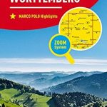 Baden-Wurttemberg Marco Polo Regional Map 11
 Mongolia Gizi Road Map
 Owerri – Imo State Road Map
 Texas USA 09 Hallwag Road Map
 Mongolia Road Edition Wall Map
 Lithuania & Kaliningrad Jana Seta Road Map
 Alaska – Dempster and Dalton Highways ITMB Road Atlas
 Costa Rica NGS Wall Map PAPER
 Australia: Hema State Road Maps
 Great Lakes USA 03 Hallwag Road Map
India Road Edition Wall Map
Great Lakes USA 03 Hallwag Road Map
India Road Edition Wall Map
 Poland Road Map
 USA: Antenna Audio American Highway Road Atlas – A4, PAPERBACK
 India Gizi Road Map
Australia Hema Road & Terrain Map
India Gizi Road Map
Australia Hema Road & Terrain Map
 Deep South USA 10 Hallwag Road Map
 USA Interstate Borch Road Map
 South Africa – Namibia – Botswana Hallwag Road Map
 USA: Hallwag Regional Road Maps
Bavaria South – Munich – Upper Bavaria K+F Road Map 8
USA: Hallwag Regional Road Maps
Bavaria South – Munich – Upper Bavaria K+F Road Map 8
 Japan South ITMB Railway & Road Map
 Namibia F&B