Disclosure : This site contains affiliate links to products. We may receive a commission for purchases made through these links.
Avon Ring and Droitwich Ring Heron Map
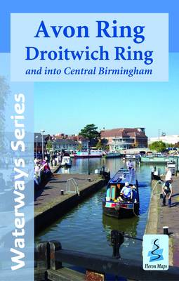
Kennet and Avon Canal and River Avon double sided map at 1:50,000 by Heron Maps offers both navigation and tourist information and includes many small detailed town plans at 1:12,500.The map divides the canal in three sections and illustrates its corridor and its proximities. Colouring distinguishes urban, woodland and areas of outstanding beauty. Motorways A and B roads, railways lines and stations are marked as well as paths, tracks and National Cycle Routes. In particular, the map shows the National Cycle Route 4 and crossings routes between Reading and Bristol. Waterway information includes marinas and boatyards, towpath, distance indicator at 1 mile apart, winding areas, locks etc. Navigation information includes visitor moorings, boat hire centres, facilities for the boat user, rowing, sailing and boat clubs, etc. Additionally, local navigation advice and warnings feature along the canal. Tourist information includes information centres, shops, places of interest, pubs, nature reserves, parks, churches, national cycle routes, long distance paths, public toilets, youth hostels, caravan and camp sites etc.One side of the map features the first (and navigable) section of the river Avon from Bristol to Melksham and the Kennet and Avon canal from Bath to Horton Bridge. It also includes small town plans inserts of Bristol, Bath, Bradford-on-Avon, Devizes and an interesting introduction to the history and facts of the canal. The reverse features the remaining two sections of the canal from Horton Bridge to Reading and town plans of, Hungerford, and Reading. Both sides of the map are annotated with historical and tourist information of places of interest and illustrated with colour pictures.To see the list of other titles in this series, please click on the series link.

Related Products:
 Kennet & Avon Canal – River Avon Heron Map
 The Kennet & Avon Towpath Guide
 Stourport Ring & Droitwich Ring Heron Map
 Four Counties Ring & Caldon Canal Heron Map
 Warwickshire Ring, Ashby-de-la-Zouch Canal & up to Fradley Junction Heron Map
 The Kennet and Avon Canal: The Full Canal Walk and 20 Day Walks
 Kennet & Avon Canal and River Thames Pearson`s Canal Companion
 Grand Union Canal – Braunston to Kings Langley Heron Map
 Shropshire Union Canal, incl. Middlewich Branch & up to Gr. Haywood Junction Heron Map
 Llangollen and Montgomery Canal Heron Maps
 Pearson`s Canal Companion – Severn and Avon: Mid-Worcestershire Ring and Cotswold Canals
 The Bristol Avon: From Source to Sea
 Grand Union Canal – Birmingham to Milton Keynes Heron Maps
 Queen of Waters:A Journey in Time Along The Kennet & Avon Canal
 River Thames and the Thames Path Heron Maps
 Birmingham Canal Navigations Heron Map
 Oxford Canal: Oxford to Hawkesbury Junction & to Coventry Basin Heron Map
 River Thames & Thames Path Heron Map
 Monmouthshire and Brecon Canal – and Crumlin Arm Heron Map
 Leeds and Liverpool Canal – Liverpool to Keighley Heron Map
 Grand Union Canal: Braunston to Kings Langley Heron Map
 Grand Union Canal: Milton Keynes to London, with the London & East London Rings Heron Map
 Clare Phillips Bristol Avon Gorge Tea Towel
 Grand Union Canal: Stoke Bruerne to Leicester, River Soar & Erewash Canal Heron Map
 Bath to Bournemouth Sustrans Cycle Route Map
 Braemar, Tomintoul & Glen Avon OS Explorer Map OL58 (paper)
 Stratford-upon-Avon & Evesham – Alcester OS Explorer Map 205 (paper)
 Braemar, Tomintoul & Glen Avon OS Explorer Active Map OL58 (waterproof)
 Stratford-upon-Avon & Evesham – Alcester OS Explorer Active Map 205 (waterproof)
 Chippenham & Bradford-on-Avon – Trowbridge & Melksham OS Explorer Map 156 (paper)
 Chippenham & Bradford-on-Avon – Trowbridge & Melksham OS Explorer Active Map 156 (waterproof)
 Bigbury, Avon & Erme Walking Map 22
 Cheshire Ring and South Pennine Ring Pearson`s Canal Companion
 Severn, Avon & Birmingham Collins Nicholson Waterways Guide 2
 Stratford-upon-Avon, Warwick & Banbury OS Landranger Map 151 (paper)
Great Britain: Heron Canal Maps
Stratford-upon-Avon, Warwick & Banbury OS Landranger Map 151 (paper)
Great Britain: Heron Canal Maps
 Worcester & Droitwich Spa OS Explorer Map 204 (paper)
 Stratford-upon-Avon, Warwick & Banbury OS Landranger Active Map 151 (waterproof)
 Worcester & Droitwich Spa OS Explorer Active Map 204 (waterproof)
 Waterways Guide 2 – Severn, Avon & Birmingham