Disclosure : This site contains affiliate links to products. We may receive a commission for purchases made through these links.
Austria Railway Atlas
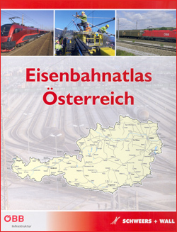
Detailed atlas of the Austrian rail infrastructure, in hardback format, published by Schweers & Wall. In addition to the pages covering the country at 1:150,000, there are larger scale detailed plans, at a scale of 1:50,000, for selected urban areas including Vienna, Linz, Salzburg, Innsbruck, Graz and Villach. Tram and Metro networks in Vienna, Linz, Innsbruck and Graz are also shown.The cartography distinguishes the many variations in the railway network: public, tourist and private lines, local and main lines, double and single track, abandoned and out of use lines, narrow gauge lines, cableways, rack railways, metros and tramways. Colours also indicate electrical system variations, and tunnels, stations, crossovers, marshalling yards, sidings, workshops, etc. are indicated. Additional details include cumulative distances at stations, gradients, national and provincial borders, motorways, industrial works, rivers, lakes and forested areas. Hill shading shows the general relief and altitudes of stations and selected peaks are shown.The legend is in German, English, French and Italian, and introductory text is in English and German. Operating companies are listed and general maps portray various themes eg. private railways, terminals, narrow guage railways, rail traffic density. The atlas is indexed for place names and tunnels.

Related Products:
 Austria F&B Roads & Cities Atlas
 Austria F&B Postcode Map
 Austria F&B Great Travel Atlas
 China Railway Atlas
 Vienna F&B Street Atlas
 Rail Atlas Europe
 Birmingham and West Midlands Railway Atlas
 An Atlas of the Railways in South West and Central Southern England
Greater Vienna F&B Street Atlas
An Atlas of the Railways in South West and Central Southern England
Greater Vienna F&B Street Atlas
 Austria Climbing and Bouldering Map
 Vienna F&B Pocket Atlas
 London Railway Atlas
 Europe Travellers` Railway Map
 The Great Indian Railway Atlas
 ABC British Railway Atlas
 Russia Railway Atlas – Russia and the former Soviet Republics
 Atlas of the Southern Railway
 Railway Atlas of Ireland Then & Now
 Austria F&B Motorcycle Road Atlas
 British Railway Atlas, 1955
 Austria Freytag & Berndt Hiking Atlas
 Scotland & Isle of Man Railway Track Diagrams Book 1
 Japan Railway & Road ITMB Travel Atlas
 Tokyo City Atlas – a Bilingual Guide
 Great Britain and Ireland: Quail Railway Track Diagrams
 Austria – Liechtenstein – South Tyrol Marco Polo Road Atlas
 Bradshaw`s Continental Railway Guide: 1853 Railway Handbook of Europe
 Austria F&B Road Atlas
 Lower Austria – Vienna – Upper Austria – Northern Burgenland 200K Marco Polo Zoom Map
 Kolkata / Calcutta Street Atlas
 Mountains around Vienna Freytag & Berndt Hiking Atlas
 Budapest Pocket Atlas
 Getting Around Tokyo Pocket Atlas and Transportation Guide
 The Railway Atlas of Scotland: Two Hundred Years of History in Maps
 Rail Guide 2019: Light Rail & Heritage Railway
 ABC London Railway Atlas
 Sweden F&B Road Atlas
 Ukraine Kartografija Road Atlas 500K HARDBACK
Ukraine Road Atlas (500K, Spiral-bound)
Ukraine Kartografija Road Atlas 500K HARDBACK
Ukraine Road Atlas (500K, Spiral-bound)