Disclosure : This site contains affiliate links to products. We may receive a commission for purchases made through these links.
Austria Michelin
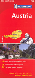
The Michelin National road map of Austria at 1:400,000 scale is ideal for route planning and touring. The map gives comprehensive coverage of national road networks showing all major motorways, dual carriageways, national & regional main roads and some single-lane roads. Also shows unsurfaced roads and tracks and major footpaths. The map is divided by grid showing latitude and longitude. Distances between major locations are marked along roads, with total distance and several intermediate distances shown. A quick-reference chart of distances & driving times between major locations is also included. The map also includes a grid-referenced index of principal place names. Clear, easy-to read cartography shows roads in reds, yellows and white with black outlines. Major topography is indicated with relief shading. Woodland & forest is marked with green shading. Built-up urban areas are clearly marked in yellow. Airports, ferries (with listed weight limits), railways are also marked. National and administrative divisions are marked. Not only are sites of interest marked, they are marked in some cases to correspond with their respective parts as featured in Michelin’s Green Guide to Austria. Also includes a quick reference panel giving national driving regulations, including speed limits, equipment requirements (e.g. bulb kits, warning triangles) and seatbelt rules, for all countries principally shown. City plans & regional enlargements:- Vienna at scale 1:100,000- Salzburg at scale 1:70,000

Related Products:
 Sweden Michelin
 Poland Michelin
 Portugal – Madeira Michelin
 Finland Michelin
 Norway Michelin
 Hungary Michelin
 Baltic States Michelin
 Czechia Michelin
 Czechia – Slovakia Michelin
 Slovenia – Croatia – Bosnia-Herzegovina – Serbia – Montenegro – North Macedonia Michelin
 Czechia – Slovakia Michelin SUPERCEDED
 Romania Michelin
 Ivory Coast Michelin
 Greece Michelin
 Germany – Benelux – Austria – Czechia Michelin
 Latvia Regio Manors and Palaces
 Wales – South West England – Midlands Michelin Regional 503
 Northern England – Midlands Michelin Regional 502
 France Michelin Booklet Atlas
 Poland: Michelin Regional Road Maps
 South East England – Midlands – East Anglia Michelin Regional 504
 Scotland Michelin Regional 501 WATERPROOF
 Scotland Michelin Regional 501
 Great Britain: Michelin 400K Road Maps
 Austria Michelin Green Guide
 Southeastern USA Michelin Regional 584
 Sicily Michelin Local 365
 Sardinia Michelin Local 366
 New England – Hudson Valley Michelin Regional 581
 Emilia-Romagna Michelin Local 357
 USA: Michelin Regional Road Maps
 Piemonte – Aosta Valley Michelin Local 351
 Italy: Michelin 200K Regional Road Maps
 Trentino-Alto Adige Michelin Local 354
 France Southwest Michelin
 Campania – Basilicata Michelin Local 362
 Umbria – the Marches Michelin Local 359
 Galicia Michelin Regional 571
 Poland South West Michelin Regional 557