Disclosure : This site contains affiliate links to products. We may receive a commission for purchases made through these links.
Austria: Freytag & Berndt Cycling Maps
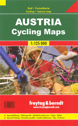
Cycling routes in Austria on two types of maps from Freytag & Berndt: route maps for the main long-distance cycling trails and detailed recreational maps overprinted with a network of local cycling routes for exploring the countryside by bike.LONG-DISTANCE CYCLE ROUTES (RK1, RK2, etc): each title is a concertina map showing the route on 12x20cm panels. Unpaved parts, sections with heavy motor traffic, and danger points are marked. The maps also indicate bike rental and repair facilities, various types of accommodation, tourist information centres, etc. Places of interest are highlighted, railway lines show local stations and stops, and nearby mountain bike tours are marked. Each map panel has next to it brief descriptions of main sights and lists of useful addresses (including accommodation) for the area. Also included are street plans of main towns, and an overall elevation profile of the whole route. The maps have no geographical coordinates. Map legend and all the text include English.LOCAL CYCLING MAPS (RK100, RK101, etc): detailed road maps with relief shading and spot heights to indicate the topography. An overprint highlights numerous cycling routes, indicating unpaved paths, routes with heavy motorized traffic and gradient marking. Symbols mark various types of accommodation, including campsites and youth hostels, bike retail and repair facilities, viewpoints, places of interest, etc. The maps have a 10km UTM grid. Each title has on the reverse an index of localities with their UTM coordinates, street plans of main towns, and profiles of selected routes. Map legend and all the text include English.

Related Products:
 Vorarlberg Cycling Freytag & Berndt Map
 Weinviertel Cycling Freytag & Berndt Map
 Inn Bike Trail: Landeck – Passau Freytag & Berndt Map
 Kamp – Thaya – March Bike Trail Freytag & Berndt Map
 Tauern Bike Trail: Krimml – Passau Freytag & Berndt Map
 Austria: Freytag & Berndt Hiking Maps
 Austria: Freytag & Berndt 150K “Top 10 Tips” Road Maps
 Austria: Bikeline Cycling Atlases
 Germany: Freytag & Berndt “Top 10 Tips” Road Maps
 Italy: Odos Cycling maps
 Austria: Freytag & Berndt 200K Road Maps
 Norway: Freytag & Berndt Regional Road Maps
 Italy: Freytag & Berndt “Top 10 Tips” Road Maps
 Croatia: Freytag & Berndt Maps of the Croatian Coast
 Germany: Freytag & Berndt Hiking and Leisure Maps
 Germany: Freytag & Berndt 200K Regional Road Maps
 Austria/Germany/Slovenia: Kompass Hiking Maps
 Mozart Bike Trail F&B RK3
 Sweden: Freytag & Berndt Regional Road Maps
 Austria: Kรผmmerly+Frey Recreational Maps
The Ruhr Bikeline Cycling Atlas
Austria: Kรผmmerly+Frey Recreational Maps
The Ruhr Bikeline Cycling Atlas
 France: Itinerance ร Velo Cycling Guides
 Netherlands: ANWB 50K Cycling Maps
 Germany: ADFC 150K Cycling Maps
 Austria Freytag & Berndt Hiking Atlas
Germany: ADFC 75K/50K Regional Cycling Maps
Austria Freytag & Berndt Hiking Atlas
Germany: ADFC 75K/50K Regional Cycling Maps
 Gesรคuse – Ennstaler Alpen – Schoberpass Freytag & Berndt Map
 Gleinalpe – Lippizanerheimat – Leoben – Voitsberg Freytag & Berndt Map
 Attersee – Mondsee – Wolfgangsee Freytag & Berndt Map
 Otscherland – Mariazell – Erlauftal – Lunzer See – Scheibbs Freytag & Berndt Map
 Slovenia: Kompass 75K Hiking and Cycling Maps
 Austria: Freytag & Berndt Hiking Atlases
 Saualpe – Lavanttal – Koralpe – Region Schlicherheimat Freytag & Berndt Map
Saltzkammergut Cycling Atlas
Saualpe – Lavanttal – Koralpe – Region Schlicherheimat Freytag & Berndt Map
Saltzkammergut Cycling Atlas
 Bohemian Forest – Mรผhlviertel – Moldau/Vltava Reservoir Freytag & Berndt Map
 Germany: Kompass 125K Cycling 2-Map Sets
 Thayatal National Park – Znaim – Retz – Gars am Karp Freytag & Berndt Map
Moststrasse Cycling Atlas
Lower Austria Rivers Cycle Paths Bikeline Map-Guide
Thayatal National Park – Znaim – Retz – Gars am Karp Freytag & Berndt Map
Moststrasse Cycling Atlas
Lower Austria Rivers Cycle Paths Bikeline Map-Guide