Disclosure : This site contains affiliate links to products. We may receive a commission for purchases made through these links.
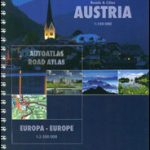
Austria F&B Great Travel Atlas
Austria Great Road and Leisure Atlas at 1:150,000 from Freytag & Berndt in a handy 15x26cm hardback format, with street plans of 64 towns, descriptions of the country’s 150 top sights, plus mapping of the whole of Europe for planning the journey to Austria.Cartography is the same as in the publishers’ very popular ‘Top 10 Tips” series of folded regional road maps of Austria. Relief shading presents the country`s terrain, with plenty of spot heights and names of peaks, mountain ranges, valleys and other geographical features. Road network includes minor local roads and tracks and indicates toll roads, gradients, seasonal closures, roads closed to or not recommended for caravans, roads closed to motorized traffic, scenic roads and special tourist routes, etc. Railway lines are shown with stations, motor-rail services are indicated, and various types of mountain lines (cable cars, funiculars, etc) are marked. Picturesque towns and villages as well as numerous other interesting sites are highlighted. The maps also show locations of campsites, youth hostels and alpine huts. No geographical coordinates are indicated. Extensive index lists locations with their postcodes. Map legend includes English.A 137-page section of the atlas is devoted to Austria’s 150 top sights, ranging from towns and villages to natural sites, each presented with a description in German English and Italian, plus cross-referenced to the road maps.The atlas also includes:- City centre street plans of 64 towns, including popular tourist resorts such as Kitzbรผhel, Zell am See, Schladming or Kufstein. Most plans are half-page size, but with larger cities like Vienna, Innsbruck, Salzburg or Graz presented on two whole pages. * Overview mapping of the country at 1:1,000,000 for route planning, highlighting the 150 top sights recommended in the atlas.* Coverage of Europe at 1:3,500,000 for route planning with an index of localities.* Comprehensive distance tables for Austria and for central Europe.


