Disclosure : This site contains affiliate links to products. We may receive a commission for purchases made through these links.
Australia West Reise Know-How
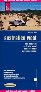
Indexed, waterproof and tear-resistant road map Western Australia at 1:1,800,000 with topographic and tourist information, published by Reise Know-How as part of their highly acclaimed World Mapping Project. The map is double-sided to provide the best balance between a good scale and a convenient size sheet. The map covers the state of Western Australia, with its northern side extending just short of the state boundary, and on the southern side just beyond it.The region’s topography is shown by altitude colouring with contours and spot heights, plus swamps, seasonal rivers and lakes, and names of various mountain ranges, peaks, deserts, etc. Road network indicates unsurfaced roads and includes outback tracks, showing names of the highways connecting main cities and driving distances on main routes. Numerous national and state parks, including marine parks, are marked, as well as aboriginal land and restricted access military zones. Symbols indicate locations of caravan and campsites, and highlight various places of interest, viewpoints, etc. The map has a latitude/longitude grid at intervals of 1ยบ and an index of localities. Map legend includes English.PLEASE NOTE: Reise Know-How’s maps of Eastern and Western Australia at 1:1,800,000 when combined do not provide coverage of the whole country but leave a large gap in the middle, particularly in the north.

Related Products:
 Australia Eastern Reise Know-How
 Australia Reise Know-How
 Canada West Reise Know-How
 India Northwest Reise Know-How
 South West Western Australia Hema
 Russia West Reise Know-How
 Africa West – Coastal Countries Reise Know-How
 Western Australia Hema
 USA Reise Know-How
 Poland Southeast Reise Know-How
 Mid West Western Australia Hema
 Africa West – Sahara Reise Know-How
 China West Reise Know-How
 Latvia Reise-Know-How
 Mallorca West Reise Know-How
 Poland Southwest Reise Know-How
 Western Balkans Reise Know-How
 California Reise Know-How
 United Arab Emirates – Dubai – Abu Dhabi Reise Know-How
 Australia UBD Gregory`s Touring Atlas A3
 Australia Hema Road & 4WD Atlas PAPERBACK
 Lithuania Reise Know-How
 Poland: Reise-Know-How Touring Maps with Historic Place Names
 Myanmar / Burma Reise Know-How
 USA Northwest – OR, WA Reise Know-How
 Armenia Reise Know-How
 Bulgaria Reise Know-How
 Cameroon & Gabon Reise-Know-How Map
 India South Reise Know-How
 Australia Hema Road & 4WD Touring Atlas A4 SPIRAL-BOUND
 Australia: Hema State Road Maps
 Hungary Reise Know-How
 Estonia Reise Know-How
 Ukraine Reise Know-How
 Australia Hema Handy Atlas SPIRAL-BOUND
 Baltic States Reise Know-How
 Iran Reise Know-How
 Australia UBD Gregory`s Concise Motoring Atlas
 Angola Reise Know-How
 Madagascar Reise Know-How