Disclosure : This site contains affiliate links to products. We may receive a commission for purchases made through these links.
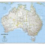
Australia Columbus Globes Political / Physical Wall Map
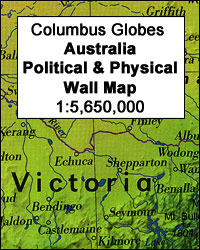
Australia on a high quality, double-sided wall map, size 115 x 85cm (45″ x 33.5″ approx), from Columbus Globes presenting on one side a political map of the country and on the reverse a physical image. Coverage extends eastwards to include New Zealand, New Caledonia and Vanuatu, and north to show most of the Solomon Islands, the southern coast of New Guinea, and the Lesser Sunda Islands of Indonesia including East Timor.On one side is a political map in light, bright colours, with international boundaries enhanced by darker colouring. Relief shading shows the topography not only on land but also of the sea floor, and the map has plenty of names of mountain ranges, peaks, deserts, etc. No information on road or railway networks is included but the administrative borders of the individual Australian states are marked.On the reverse is a physical map with the same coverage. The map carries the same information as the political side, but with colours for countries replaced by altitude colouring. On both sides latitude and longitude lines are drawn at 5ยฐ intervals. The map is printed on high quality glossy paper with bright shining surface.

Related Products:
 North America Columbus double-sided Political / Physical Wall Map
 World Down Under Political – Physical Map UBD Gregory`s
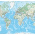
 World Political/Physical – Sea Relief F&B Wall Map LAMINATED with Metal Hanging Strips
 World: Freytag & Berndt Political/Physical World Wall Maps
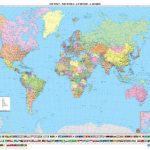
 World F&B Political Wall Map LARGE
 World K+F Physical 30M Wall Map MEDIUM MAGNETIC-BOARD
 World Schofield & Sims Political Wall Map
 World F&B Political Wall Map MEDIUM
 World & Flags Hema Political Pacific-Centred
 World Maps International Executive Political Wall Map
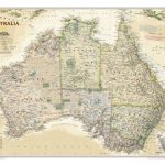 Australia NGS Executive Wall Map PAPER
 World K+F Political 30M Wall Map LAMINATED
 World K+F Physical 30M Wall Map LAMINATED
 World K+F Political 30M Wall Map MEDIUM PIN-BOARD
 World F&B Political Wall Map MEDIUM – with Metal Hanging Strips
 World: Freytag & Berndt Political Wall Maps
 World Political – Sea Relief F&B Wall Map LAMINATED
 World F&B Political – Sea Relief Wall Map XXL LAMINATED
 World 3 Global Views Raven Maps Physical Wall Map
 Australia NGS Executive Wall Map ENCAPSULATED
 Kazakhstan Political Wall Map
 An Uncommon Atlas: 50 new views of our physical, cultural and political world
 World Maps International Political UPSIDE-DOWN Wall Map LARGE PAPER
 Europe IGN Political Wall Map
 World Maps International Political Upside-down Wall Map LARGE HANGING-STRIPS
 World: Kรผmmerly + Frey Political Wall Maps
 World Norstedts Black & White Political Wall Map
 World Collins Political Wall Map LAMINATED
 Australia NGS Classic Wall Map PAPER
 South Australia State & Suburban UBD Gregory`s 570
 Australia NGS Classic Wall Map ENCAPSULATED
 World Maps International Physical Wall Map LARGE HANGING-STRIPS
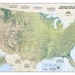 United States NGS Physical Wall Map PAPER
 Future Mapping Co. Sinu-Mollweide Political World Wall Map V.2: blue/emerald/pink/yellow PAPER
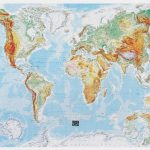 World Physical / Le Monde Physique IGN Wall Map
 Australasia Political Wall Map: HANGING STRIPS
 World Maps International Political Upside-down Wall Map LARGE ENCAPSULATED
 Canary Islands Autonomous Region 350K CNIG Physical Road Map
 South America Global Mapping Political Wall Map PAPER
 South Australia Hema