Disclosure : This site contains affiliate links to products. We may receive a commission for purchases made through these links.
Ateca
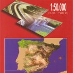
Map No. 437 โ€“ Ateca is part of the topographic coverage of Spain at 1:50,000 in the MTN50 (Mapa Topogrรกfico Nacional) series from the Instituto Geogrรกfico Nacional โ€“ Centro Nacional de Informaciรณn Geograficรก, the countryโ€s civilian survey organization.The maps have contours at 20m intervals, enhanced by relief shading, plus colouring and/or graphics to show different types of terrain, vegetation or land use. Boundaries of national parks and other protected areas are marked. In addition to all the usual information shown on topographic maps at this scale, detailed presentation of the road and rail networks, rural tracks and paths, etc, the maps also show campsites and mountain refuges. On more recent editions some GRs, the official long-distance hiking routes, are also marked (although not as clearly as on hiking maps from other publishers).A small inset shows local administrative boundaries and a table of UTM coordinates for triangulation points is also provided. Each map covers an area of 27×18 km (17×11 miles approx.) The maps have a 1-km UTM grid, with margin ticks for latitude and longitude at 5` intervals. Map legend is in Spanish only.*PLEASE READ THE NOTES BELOW BEFORE ORDERING!**Map Titles:*The grids shown on our website serve both the civilian and the military 1:50,000 topographic series. Although the areas covered by sheets in both series are identical (apart from some border or coastal sheets), occasionally map titles differ โ€“ only one title is shown on the grid, usually the military one.Map titles listed on our website are based on information received by us at the time of publication, but sometimes maps arrive showing a completely different title! *As long as the map number is as ordered, the correct map has been supplied.*In Galicia, the Basque country and in the Catalan speaking areas the tendency now is to use local place names rather than the often better known Castilian names. Where possible, both versions are included in our titles. *Publication dates:*MTN50 series was begun in late 1990s, with most sheets listed here published in 2000s. Numbers not included on our website may still be available in the previous series but the maps will be very old, some dating back to 1940s or 1950s. If required, please contact us by e-mail.*How to choose the right 1:50,000 map:*All the titles in the [LINK: 1800|caption: IGN 200K Provincial Road Maps series at 1:200,000] are overprinted with the grid for the 1:50,000 maps and can be used to see precisely the area covered by each 50K title.

Related Products:
 Ateca CNIG Topo 437
La Baรฑa
Ateca CNIG Topo 437
La Baรฑa
 Spain: 50K Mainland Spain Civilian Topographic Survey
Granada Norte CNIG Topo 1009
Spain: 50K Mainland Spain Civilian Topographic Survey
Granada Norte CNIG Topo 1009
 Purullena CNIG Topo 1010
Roa CNIG Topo 345
Purullena CNIG Topo 1010
Roa CNIG Topo 345
 Buendia CNIG Topographic Map 562-3
Foz CNIG Topo 9
Leรณn CNIG Topo 161
La Baรฑa CNIG Topo 229
Ibi CNIG Topo 846
Coy CNIG Topo 932
Buendia CNIG Topographic Map 562-3
Foz CNIG Topo 9
Leรณn CNIG Topo 161
La Baรฑa CNIG Topo 229
Ibi CNIG Topo 846
Coy CNIG Topo 932
 Oรฑa CNIG Topo 136
Vic CNIG Topo 332
Used CNIG Topo 464
Oรฑa CNIG Topo 136
Vic CNIG Topo 332
Used CNIG Topo 464
 Granada Sur CNIG Topographic Map 1026
Boรฑar CNIG Topo 104
Orduรฑa CNIG Topo 111
A Gudiรฑa CNIG Topo 266
Tirteafuera CNIG Topo 809
Granada Sur CNIG Topographic Map 1026
Boรฑar CNIG Topo 104
Orduรฑa CNIG Topo 111
A Gudiรฑa CNIG Topo 266
Tirteafuera CNIG Topo 809
 Plasencia CNIG Topo 598
Banyoles CNIG Topo 295
Anchuras CNIG Topo 709
Montalban CNIG Topo 493
Plasencia CNIG Topo 598
Banyoles CNIG Topo 295
Anchuras CNIG Topo 709
Montalban CNIG Topo 493
 Valladolid CNIG Topo 372
Caudete CNIG Topo 819
Valladolid CNIG Topo 372
Caudete CNIG Topo 819
 Constantina CNIG Topo 920
Fuentespina CNIG Topo 375
Olvega CNIG Topo 351
La Velles CNIG Topo 452
Constantina CNIG Topo 920
Fuentespina CNIG Topo 375
Olvega CNIG Topo 351
La Velles CNIG Topo 452
 Aracena CNIG Topo 917
Buron CNIG Topo 80
Reinosa CNIG Topo 83
Alpera CNIG Topo 792
Aracena CNIG Topo 917
Buron CNIG Topo 80
Reinosa CNIG Topo 83
Alpera CNIG Topo 792
 Cullar CNIG Topo 972
Mira CNIG Topo 665
Cullar CNIG Topo 972
Mira CNIG Topo 665
 Benissa CNIG Topo 822
Elda CNIG Topo 871
Benalua CNIG Topo 993
Baza CNIG Topo 994
Benissa CNIG Topo 822
Elda CNIG Topo 871
Benalua CNIG Topo 993
Baza CNIG Topo 994