Disclosure : This site contains affiliate links to products. We may receive a commission for purchases made through these links.
Arosa – Davos Swisstopo Hiking 3309T
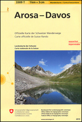
Arosa – Davos area at 1:33,333 on light, waterproof and tear-resistant map No. 3309T published by Swisstopo in cooperation with the Swiss Hiking Federation. Cartography is the same as in Swisstopo’s 50K hiking maps, simply enlarged to 1:33,333 for extra clarity but without additional information. Coverage includes Klosters, Lenzerheide/Lei and Chur. The title includes a table with timings and facilities for three recommended routes: Weisshorn to Arosa and tours from Davos Dorf and Schatzalp.1:33,333 editions of Swisstopo’s hiking maps have cartography identical to the standard version of the country’s 1:50,000 topographic survey, highly regarded for its superb use of graphic relief and hill shading to provide an almost 3-D picture of Switzerland`s mountainous terrain. Contours are at 20m intervals. An overprint highlights routes maintained by the SHF, distinguishing between hiking routes, mountain routes requiring proper footwear, and alpine routes where equipment is needed. Paths which are part of the national or regional network of long-distance hiking routes are specially marked and in the more recent editions are annotated with their official numbers. The maps show mountain huts, refuges and in remote areas also inns, plus roads with bus service and the positions of bus stops. All the maps have a 1-km grid of the Swiss national coordinates. For a list of all the titles in this series, please click on the series link.

Related Products:
 Davos – Arosa – Lenzerheide – Prรคttigau K+F Hiking Map 13
 Chur – Arosa – Davos Swisstopo 5002
 Prรคttigau Swisstopo Hiking 248T
Hauenstein – Belchenflue Swisstopo Hiking 3325T
Lugano – Mendrisiotto Swisstopo Hiking 3328T
Prรคttigau Swisstopo Hiking 248T
Hauenstein – Belchenflue Swisstopo Hiking 3325T
Lugano – Mendrisiotto Swisstopo Hiking 3328T
 Hoch-Ybrig Swisstopo Hiking 3312T
 Thunersee ‘“ Brienzersee Swisstopo Hiking 3322T
 Lotschental – Aletschgebiet 33K Swisstopo Hiking 3324T
 Chasseral – Vue des Alpes Swisstopo Hiking 3315T
 Schaffhausen – Klettgau – Randen – Stein am Rhein Swisstopo Hiking 3329T
 Lac de Joux – Mont Tendre – Col du Marchairuz Swisstopo Hiking 3316T
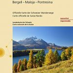 St. Moritz – Bergell – Maloja – Pontresina Swisstopo Hiking 3320T
 Weissenstein – Moron – Balmberg – Hohe Winde Swisstopo Hiking 3318T
 Napf ‘“ Sorenberg – Schupfheim – Escholzmatt – Schratteflue Swisstopo Hiking 3321T
 Col du Marchairuz Swisstopo Hiking 460T
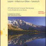 Les Diablerets – Leysin – Villars-sur-Ollon – Sanetsch Swisstopo Hiking 3317T
 Creux du Van – Ste Croix – Val de Travers – Gorges de l`Areuse Swisstopo Hiking 3303T
 Andermatt – Urseren – Gotthard – Oberalp – Lago Ritom Swisstopo Hiking 3314T
Liestal Swisstopo Hiking 214T
Andermatt – Urseren – Gotthard – Oberalp – Lago Ritom Swisstopo Hiking 3314T
Liestal Swisstopo Hiking 214T
 Frauenfeld Swisstopo Hiking 216T
 Olten Swisstopo Hiking 224T
 Rapperswil Swisstopo Hiking 226T
Willisau Swisstopo Hiking 234T
Lachen Swisstopo Hiking 236T
Rapperswil Swisstopo Hiking 226T
Willisau Swisstopo Hiking 234T
Lachen Swisstopo Hiking 236T
 Val de Travers Swisstopo Hiking 241T
 Avenches Swisstopo Hiking 242T
 Bern Swisstopo Hiking 243T
Escholzmatt Swisstopo Hiking 244T
Bern Swisstopo Hiking 243T
Escholzmatt Swisstopo Hiking 244T
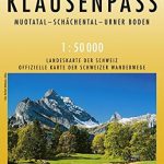 Klausenpass Swisstopo Hiking 246T
 La Sarraz Swisstopo Hiking 251T
Safiental Swisstopo Hiking 257T
San Bernardino Swisstopo Hiking 267T
Malcantone Swisstopo Hiking 286T
La Sarraz Swisstopo Hiking 251T
Safiental Swisstopo Hiking 257T
San Bernardino Swisstopo Hiking 267T
Malcantone Swisstopo Hiking 286T
 Safiental – Lenzerheide Swisstopo Hiking 3310T
 Sรคntis – Toggenburg – Churfristen – Alpstein Swisstopo Hiking 3301T
 Stans Swisstopo Hiking 245T
 Clos du Doubs Swisstopo Hiking 222T
 Vallon de St-Imier Swisstopo Hiking 232T
 Valle Leventina Swisstopo Hiking 266T
 Valle Antigorio Swisstopo Hiking 275T