Disclosure : This site contains affiliate links to products. We may receive a commission for purchases made through these links.
Argentina F&B
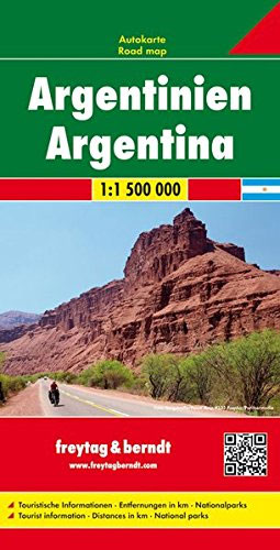
Argentina at 1:1,500,000 on a large, double-sided map from Freytag & Berndt presenting the country on three overlapping panels, with an index booklet attached to the map cover also providing street plans Buenos Aires, Cรณrdoba and Rosario.The map divides the country north/south. On one side is northern Argentina, extending south to include Mendoza and Aconcagua, San Luis, Rio Cuarto and Rosario, plus the northern half of Uruguay, coverage of much of Paraguay including Asuncion, and parts of north-eastern Chile. On the reverse the remainder of the country is presented on two panels; coverage on the main panel starts in San Luis, extending east and west to Montevideo and Santiago, and continues southwards along the Andes beyond El Chaltรฉn. The remainder of Patagonia and Terra del Fuego are on the third panel; coverage here includes Torres del Paine National Park and the Chilean islands south of it.Bold relief shading and colouring for the Andes, with plenty of names of geographical features, do not detract from the presentation of road network which is graded into six types and shows locations of petrol stations. Tourist routes are highlighted. Railway lines are included and local airports are marked. Symbols indicate various places of interest including campsites. National parks and other protected areas are highlighted. The map also shows administrative boundaries with names of the provinces, and indicates numerous oil fields and pipelines. Latitude and longitude lines are drawn at 1ยบ intervals. The index is in a booklet attached to the map cover, which also provides street plans of central Buenos Aires, Cรณrdoba and Rosario. Also included is a map of the Falkland Islands at the same scale as the main map; place names are in English (Stanley, etc). Map legend includes English.

Related Products:
 Argentina North – Uruguay Nelles
 Argentina North & Uruguay ITMB
 South America – The Andes Nelles
 Argentina South & Tierra del Fuego ITMB
 Argentina ACA Regional Zone 4 – Region Centro
 Argentina Reise Know-How
 Argentina Borch
 Buenos Aires & Argentina North East ITMB
 Argentina NGS Adventure Map 3400
 Chile – Argentina Michelin
 Argentina ACA Regional Zone 7 – Patagonia North
 Argentina ACA Regional Zone 5 – Region Cuyo (incl. Aconcagua – Mendoza – San Luรญs)
 Argentina ACA Regional Zone 2 – Region Cuyo y Norte
 Argentina
 Great Britain Borch
 Texas & Oklahoma ITMB
 Quito & Central Ecuador ITMB
 Argentina Super Atlas (with Chile, Paraguay, Uruguay and South-Eastern Brazil)
 Italy North K+F Road Map
 Argentina ACA Regional Zone 9 – Patagonia South
 San Francisco & Northern California ITMB
 Italy K+F Double-Sided Road Map
 Italy North F&B
 Tehran & Northern Iran ITMB
 Istria – Kvarner
 Albania F&B
 Algeria ITMB
 South America ITMB
 Pyrenees – Costa Brava – Basque Country – Navarra – Aragon – Andorra – Catalonia
 Villarrica, Llanquihue & Chiloe
 India F&B
 Lithuania Jana Seta Road Map
 Colombia – Ecuador Nelles
 South Africa – Namibia – Botswana Hallwag Road Map
 Colombia F&B
 San Luis Potosรญ State – San Luis Potosรญ City
 Russia Western & Central with the Neighbouring States
 Vietnam – Laos – Cambodia Nelles
 South Tyrol – Bolzano F&B Top 10 Tips