Disclosure : This site contains affiliate links to products. We may receive a commission for purchases made through these links.
Aragรณn Autonomous Region 300K CNIG Physical Road Map
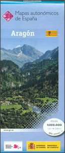
Aragรณn Autonomous Region of Spain at 1:300,000 on a large physical map from the IGN/CNIG – country’s civilian survey organization providing an excellent picture of the region’s topography, from the peaks of the highest part of the Pyrenees, across the valley of the Ebro, to the sierras of southern Teruel province. Icons prominently highlight various places of interest and facilities including campsites.Relief shading is enhanced by bright altitude colouring, with plenty of names of mountain ranges, peaks, etc, plus additional spot heights. Boundaries of national and natural parks are marked. Topographic colouring does not continue beyond Andalucรญa’s administrative boundary, although the road network and other information are included. The map shows the regional road network, from toll motorways to local country tracks, railways and local airports or aerodromes. Symbols highlight locations of paradors, ski areas, monasteries and other historical monuments, etc. The map also shows administrative boundaries of provinces within Andalucรญa and town symbols indicate their administrative status and the number of inhabitants. The map has a UTM grid, plus 1’ latitude and longitude margin ticks. Map legend is in Spanish only.PLEASE NOTE: the map is sold for its excellent presentation of the topography ‘“ the road network may not necessarily be up-to-date.To see other titles in this series please click on the series link.

Related Products:
 Canary Islands Autonomous Region 350K CNIG Physical Road Map
 Andalusia Autonomous Community CNIG Physical Road Map
Murcia Autonomous Region 200K CNIG Physical Road Map
Castilla-la-Mancha Autonomous Region 400K CNIG Physical Road Map
Andalusia Autonomous Community CNIG Physical Road Map
Murcia Autonomous Region 200K CNIG Physical Road Map
Castilla-la-Mancha Autonomous Region 400K CNIG Physical Road Map
 Cantabria Autonomous Community CNIG Physical Road Map
 Castilla y Leon Autonomous Community CNIG Physical Road Map
Castilla-La Mancha Autonomous Community CNIG Physical Road Map
Castilla y Leon Autonomous Community CNIG Physical Road Map
Castilla-La Mancha Autonomous Community CNIG Physical Road Map
 Catalonia Auotomous Community CNIG Physical Road Map
Spain: CNIG Road Maps of Autonomous Administrative Regions
Extremadura Auotomous Community CNIG Physical Road Map
Catalonia Auotomous Community CNIG Physical Road Map
Spain: CNIG Road Maps of Autonomous Administrative Regions
Extremadura Auotomous Community CNIG Physical Road Map
 Spain Autonomous Regions CNIG Wall Map
 Iceland: Mรกl og Menning 300K Road Maps
Murcia Auotomous Community CNIG Physical Road Map
Iceland: Mรกl og Menning 300K Road Maps
Murcia Auotomous Community CNIG Physical Road Map
 Yevreyska Autonomous Oblast Road Atlas
 Crimea Autonomous Republic
 Caucasus Road Edition Wall Map
 Catalonia Editorial Alpina Road Map
Spain CNIG Physical Wall Map
Kiev Administrative Region
Zaporizhzhia Administrative Region
Zhytomyr Administrative Region
Ternopil Administrative Region
Khmelnytskyi Administrative Region
Lviv Administrative Region
Dnipropetrovsk Administrative Region
Mikolayiv Administrative Region
Rivne Administrative Region
Vinnytsia Administrative Region
Chernihiv Administrative Region
Kharkiv Administrative Region
Cherkasy Administrative Region
Poltava Administrative Region
Kirovohrad Administrative Region
Kherson Administrative Region
Chernivtsi Administrative Region
Sumy Administrative Region
Volynska Oblast Administrative Region
Catalonia Editorial Alpina Road Map
Spain CNIG Physical Wall Map
Kiev Administrative Region
Zaporizhzhia Administrative Region
Zhytomyr Administrative Region
Ternopil Administrative Region
Khmelnytskyi Administrative Region
Lviv Administrative Region
Dnipropetrovsk Administrative Region
Mikolayiv Administrative Region
Rivne Administrative Region
Vinnytsia Administrative Region
Chernihiv Administrative Region
Kharkiv Administrative Region
Cherkasy Administrative Region
Poltava Administrative Region
Kirovohrad Administrative Region
Kherson Administrative Region
Chernivtsi Administrative Region
Sumy Administrative Region
Volynska Oblast Administrative Region
 Zakarpatska Oblast Administrative Region
Ivano-Frankivsk Administrative Region
Zakarpatska Oblast Administrative Region
Ivano-Frankivsk Administrative Region
 Andalucรญa West: Cรณrdoba – Seville – Mรกlaga 500K CNIG Regional Map No. 11