Disclosure : This site contains affiliate links to products. We may receive a commission for purchases made through these links.
Antuco – Laguna del Laja National Park
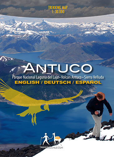
Antuco – Laguna del Laja National Park ‘“ Volcรกn Antuco ‘“ Sierra Velluda area at 1:30,000 in a series of contoured, GPS compatible trekking and exploration maps at various scales form Trekkingchile. The map has contours at 50m intervals, with graphics/colouring to show glaciers and different types of vegetation. Road network indicates paved or gravel roads and dirt tracks. The map shows trekking routes with distances and symbols highlight various places of tourist interest: campsites, cabins and other types of accommodation, restaurants, animal observation points, fishing tours and boat trips, etc. Coverage extends from Abanico to the lake and north/south from the Lagunas Las Cรณndores pass to the peak of Cordรณn Petronquines. The map has a UTM grid and latitude longitude margin ticks at 1’. Map legend includes English.On the reverse are colour drawings of local fauna plus several English language advertisements for various services.Maps in the Trekkingchile series use satellite imagery as a base, with contour lines and colouring to indicate different types of terrain and habitats. Unless indicated to the contrary in the individual descriptions, the maps have a UTM grid, plus margin ticks for latitude and longitude. The maps are annotated with tourist information and most titles include a street plan of the region’s main town. Many are illustrated with drawings of local fauna or flora. Map legends and other text include English.To see the other titles in this series please click on the series link.

Related Products:
 Laguna del Maule – Winter Trails
 Huilo Huilo Biological Reserve Trekkingchile Map
 Rรญo Los Cipreses National Reserve
 Chile: Trekkingchile Hiking and Exploration Maps
 Puyehue
 Melado – Volcรกn San Pedro
 Santiago Environs
 Condor Circuit
Nevados de Chillรกn
Condor Circuit
Nevados de Chillรกn
 Cajรณn del Maipo – Volcรกn San Josรฉ
 Lake Llanquihue and Surrounding Region
 Costa del Maule
 Cabo Froward
 Torres del Paine 50K/100K Trekkingchile Map
 Khumbu – Sagarmatha National Park
 Galicica National Park
 Shivapuri Nagarjun National Park
 Lake Manyara National Park
 Serengeti National Park
 Tarangire National Park
 Lemmenjoki National Park
 Skaftafell National Park IDNU Map
 Folgefonna National Park Nordeca 2663
 Rio Verde – Laguna Blanca SIG Patagon
 Mavrovo National Park
 Gesรคuse National Park Kompass 206
 Sareks National Park Lantmateriet BD10
 Arusha National Park
 Picos de Europa National Park 3-Map and Guide Set CNIG ENGLISH
 Kilimanjaro National Park
 Picos de Europa National Park 3-Map and Guide Set CNIG SPANISH
 Julian Alps – Triglav National Park Kompass 064
 Aigรผestortes and Estany de Sant Maurici National Park 2-Map Set Editorial Alpina
 Bavarian Forest National Park – Nature Park East UK50-29
 Triglav National Park
 Osogovski National Park
 Glockner Group – Hohe Tauern National Park Kompass 39
 Monti Sibillini National Park Kompass 2474
 Thayatal National Park – Znaim – Retz – Gars am Karp Freytag & Berndt Map
 Monti Sibillini National Park Edizioni Multigraphic 60/61