Disclosure : This site contains affiliate links to products. We may receive a commission for purchases made through these links.
Annapurna NGS Adventure Map 3003
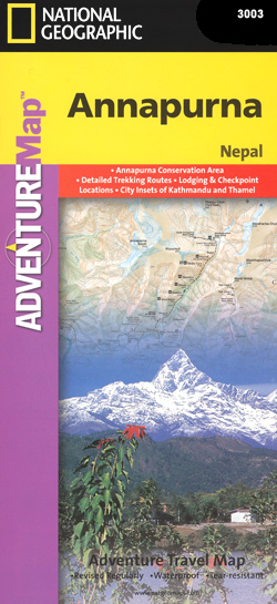
Annapurna area at 1:135,000 approx. on indexed, light, waterproof and tear-resistant hiking map, with a plan of the Kathmandu/Patan area including an enlargement of the Thamel district, plus an overview map of the whole country.The map is part of a series covering Nepal’s four most popular trekking areas. The maps were prepared by the NGS/Trails Illustrated team responsible for the highly acclaimed hiking maps of national parks in the USA, in cooperation with the Nepa Maps (Himalayan Maphouse), publishers of a wide range of trekking maps of Nepal.Contours (see below) with additional spot heights, relief shading and colouring for glaciers and forested areas present the topography of each area. The maps show settlements, roads and trekking routes, as well as extensive information for tourists: local airports, lodgings and campsites, numerous places of interest including temples, monasteries, caves, waterfalls, etc. Map ticks at intervals of 1` indicate latitude and longitude. An index of localities includes a list of peaks, passes and lakes. Sherpa spellings are used within the Khumbu area and Nepali spellings elsewhere in the country.On the reverse of each title, a general road map of the whole of Nepal highlights the country’s national parks and nature reserves. Also included is a street plan of Kathmandu with Patan, plus an enlargement for the central Thamel area of the city. The two plans highlight hotels and guesthouses, restaurants, banks, embassies and consulates, places of interest, etc.*In this title:* the map covers the whole of the Annapurna circuit between Pokhara and Jomoson. Contours are at 100m intervals and all peak heights are also given in metres. Latitude and longitude margin ticks are at 1` intervals. Please note: the cover incorrectly identifies this title as No. 3001 in the series ‘“ its correct number is 3003, as shown inside).

Related Products:
 Langtang NGS Adventure Map 3004
 Khumbu NGS Adventure Map 3002
 Everest Base Camp NGS Adventure Map 3001
 Nepal: NGS Adventure Maps
 North Annapurna Base Camp
 Mustang to Annapurna
 Annapurna
 Annapurna Himal
 Annapurna Base Camp
 Nepal Adventure Map
 Around Annapurna (100K)
 Helambu Trail
 Kanchenjunga
 Around Annapurna (125K)
 Bhairab Kund
 Panch Pokhari
 Khumbu – Sagarmatha National Park
 Annapurna, Naar & Phu Great Himalaya Trail Map
 Lukla to Tengboche
 Royal Trek
 Pokhara Valley
 Numbur Cheese Circuit
 Lumbini Buddhist Circuit Tour and the LDT Area
 Gosainkunda – Trek to Shiva`s Sacred Lake
 Chitwan: Chepang Hills Trail
 Indigenous Peoples Trail
 Nepal: Nepa Trekking and Hiking Maps
 Pokhara to Muktinath and Jomosom
 Thailand Adventure Map
 Upper & Lower Dolpo
 Peru NGS Adventure Map 3404
 Nepal Nelles
 Tumlingtar to Lukla
 Naar – Phu
 Tatopani Trek
 Naya Kanga
 South Africa Adventure Map
 Monastry Circuit Trail
 Tilicho Hidden Lake
 Dunai to Jumla and Rara Lake