Disclosure : This site contains affiliate links to products. We may receive a commission for purchases made through these links.
Alice Springs to Uluru (Ayers Rock)
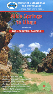
Alice Springs with the MacDonnell Ranges, Uluru (Ayers Rock), and the adjoining areas of South Australia and Western Australia states on a road map at 1:1,000,000 annotated with 40 places of interest, plus on the reverse their descriptions and more detailed mapping of the MacDonnell Ranges at 1:750,000.On one side the main road map at 1:1m has Alice Springs towards its north-eastern corner; coverage extends south into SA along the Stuart Highway to Marla, plus along the Gunbarrel Highway across north-western SA to the Rawlinson Ranges in WA. Relief shading shows the topography, with names of mountain ranges, peaks, etc. National parks and other conservation areas are highlighted and Aboriginal lands are marked. Road network includes 4WD tracks and indicates driving distances on most routes. 13 locations are cross-referenced to a list of their GPS coordinates, and symbols indicate various facilities including campsites and caravan parks, roadside rest areas, fuel supplies, etc. 40 places of reference are prominently highlighted with their descriptions provided on the reverse side. The map also shows routes taken by various early explorers of the region and is annotated with tips for present day travellers (entry permits, etc.). Latitude and longitude lines are drawn at 1ยบ intervals. On the reverse the MacDonnell Ranges either side of Alice Springs are shown in greater detail at 1:750,000.

Related Products:
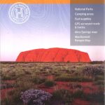 Red Centre – Alice Springs to Uluru NT Hema
 Alice Springs to Boulia
Oodnadatta to Alice Springs
Alice Springs to Boulia
Oodnadatta to Alice Springs
 Steamboat Springs CO Trail Map
 South Australia Hema
 Marlborough – Kaikoura: Nelson, Blemheim, Kaikoura, Hanmer Springs
 Colorado Springs CO Rand McNally
 Kootenay National Park Gem Trek Map
 Gulf Country QLD/NT
 Canning Stock Route
 Sydney & Australia East ITMB
 Vietnam, Laos & Cambodia ITMB
 Melbourne to Adelaide – featuring the Great Ocean Road and Victorian Goldfields Hema Touring Map
 Central Australia Hema 4WD Explorer Map
 Birdsville and Strzelecki Tracks, SA/QLD/NSW
North Island – New Zealand Hema
Birdsville and Strzelecki Tracks, SA/QLD/NSW
North Island – New Zealand Hema
 Alice in Wonderland Graphic Novel
 Highway 395 – Carson City NV to Lone Pine CA Benchmark Road Map
 North East New South Wales – Coffs Harbour to Brisbane Hema Explorer Map
 Alice in Wonderland Mad Hatter Tea Party
 What Would Alice Do?: Advice for the Modern Woman
 Palmerston North Pathfinder
 USA North-East
 Palencia
 Our lady of Alice Bhatti
 After Alice
 North East New South Wales Hema
 Alice Pack of Cards
Auckland Kiwimaps City & District Pathfinder Map
Alice Pack of Cards
Auckland Kiwimaps City & District Pathfinder Map
 Alice Tait London Pen
 Japanese Inns and Hot Springs: A Guide to Japan`s Best Ryokan and Onsen
Aspen – Glenwood Springs – Snowmass – Rifle CO
Japanese Inns and Hot Springs: A Guide to Japan`s Best Ryokan and Onsen
Aspen – Glenwood Springs – Snowmass – Rifle CO
 British Library Tenniel: Alice (Foiled Pocket Journal)
 Alice Tait London A6 Notebook Set of 3
 The Macmillan Alice Colouring Book
 Alice: 100 Postcards from Wonderland
 Alice Through the Looking Glass
 Rotorua and Taupo Pathfinder
 Kos Geopsis 212