Disclosure : This site contains affiliate links to products. We may receive a commission for purchases made through these links.
Algeria Gizi Geographical Map
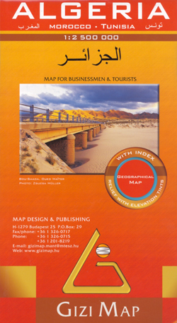
Algeria at 1:2,500,000 in a geographical version from Gizi Map, with bright altitude colouring vividly presenting the country’s topography. Names of larger towns, provinces and selected topographic features are also shown in the Arabic alphabet; all other place names are in the Latin alphabet. Where appropriate, alternative versions of place names are also provided (Oran/Wahran, etc).Bold altitude colouring with plenty of spot heights and names of mountain ranges, deserts, etc, provides a vivid picture of the country’s topography. Graphics show stone or sand deserts, salt flats, swaps and seasonal wadis, with symbols indicating oasis and water wells. Road network includes desert tracks and shows distances on main and on many secondary routes. Railway lines are includes and local airports are marked; the map also shows locations of oil or gas wells and the pipe lines, plus administrative boundaries of the provinces. Symbols mark various places of interest, including campsites, beaches, UNESCO World Heritage sites, rock paintings, archaeological remains, etc. Coverage includes all but the southernmost part of Morocco (without South Sahara), all of Tunisia, and the western part of Libya just beyond Tripoli. Latitude and longitude lines are drawn at 1ยบ intervals. The index is next to the map. Map legend includes English and Arabic.PLEASE NOTE: this title is also available as a wall map, plus in an alternative road edition where the altitude colouring has been replaced by relief shading.

Related Products:
 Algeria Geographical Wall Map
 Algeria (Road Edition)
 Algeria Road Edition Wall Map
 Morocco Gizi Map
 China Gizi Map Geographical Wall Map
 Kazakhstan Geographical Gizi Map
 Libya Geographical Edition Wall Map
 Libya Geographical Map
 Oman – United Arab Emirates Gizi Map
 Egypt Gizi Map
 Turkmenistan Gizi Map
 Turkmenistan Gizi Wall Map
 Central Asia Geographical Edition Gizi Map
 Iran Gizi Map
 Libya Gizi Road Map
 Syria Gizi Map
 Caucasus Geographical Gizi Map
 Morocco Wall Map
 Somalia Gizi Map
 Syria Gizi Wall Map
 Algeria ITMB
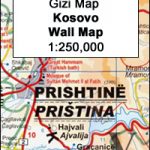 Kosovo Gizi Wall Map
 Kazakhstan Geographical Wall Map
 Middle East Gizi Map
 Algeria F&B
 Uzbekistan Gizi Map
 Pakistan Gizi Map
 Vietnam – Laos – Cambodia Gizi Map
 Uzbekistan Gizi Map Wall Map
 Saudi Arabia Gizi Map
 Mongolia (Geographical Edition)
Tajikistan – The Pamirs Gizi Map
Mongolia (Geographical Edition)
Tajikistan – The Pamirs Gizi Map
 Egypt Wall Map
 Mongolia Geographical Edition Wall Map
 Mauritania Gizi Map
 Tajikistan – The Pamirs Gizi Map Wall Map
 Kyrgyzstan Gizi Map
 Tibet Geographical Edition Wall Map
 Oman and United Arab Emirates Wall Map
 Sudan – South Sudan Gizi Map