Disclosure : This site contains affiliate links to products. We may receive a commission for purchases made through these links.
Albania: Vektor Administrative Prefecture Maps

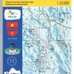
Albaniaโ€s administrative prefectures on handy size, waterproof and tear-resistant road maps from the Tirana-based publishers Vektor at scales between 1:50,000 and 1:150,000; contoured, GPS compatible, with campsites, beaches and places of interest, etc.Landscape is presented by altitude colouring and contours lines at 100m intervals, with spot heights and a few more names of topographic features than found on Vektorโ€s 200K road maps of the country. National parks and nature reserves are prominently highlighted. The prefecture maps appear to show the same small local dirt roads as in the 200K series, but given the increase in scale do so with greater clarity and also provide more detailed GPS coordinates (latitude and longitude lines are drawn at 5โ€ intervals), useful when travelling across the more remote parts of the country.Railway lines are included and local airports are marked. Symbols highlight campsites, beaches, archaeological and historical sites, caves, etc. The maps also show subdivisions of prefectures and names of the communes, and indicate administrative status of towns. Map legend includes English.Please note: border crossings are prominently marked but beyond topographic colouring no road or other information is provided outside the countryโ€s borders.

Related Products:
 Korรงa Prefecture
Tirana Prefecture
Berati Prefecture
Bulqiza Prefecture
Delvina Prefecture
Devolli Prefecture
Dibra Prefecture
Elbasani Prefecture
Fieri Prefecture
Gjirokastra Prefecture
Hasi Prefecture
Kavaja Prefecture
Kolonja Prefecture
Kruja Prefecture
Kurbini Prefecture
Lezha Prefecture
Librazhdi Prefecture
Lushnja Prefecture
Mallakastra Prefecture
Mati Prefecture
Mirdita Prefecture
Peqini Prefecture
Pogradeci Prefecture
Puka Prefecture
Saranda Prefecture
Skrapari Prefecture
Shkodra Prefecture
Tepelena Prefecture
Tropoja Prefecture
Vlora Prefecture
Gramshi Prefecture
Kuรงova Prefecture
Kukรซsi Prefecture
Pรซrmeti Prefecture
Durrรซsi Prefecture
Malรซsia e Madhe Prefecture
Korรงa Prefecture
Tirana Prefecture
Berati Prefecture
Bulqiza Prefecture
Delvina Prefecture
Devolli Prefecture
Dibra Prefecture
Elbasani Prefecture
Fieri Prefecture
Gjirokastra Prefecture
Hasi Prefecture
Kavaja Prefecture
Kolonja Prefecture
Kruja Prefecture
Kurbini Prefecture
Lezha Prefecture
Librazhdi Prefecture
Lushnja Prefecture
Mallakastra Prefecture
Mati Prefecture
Mirdita Prefecture
Peqini Prefecture
Pogradeci Prefecture
Puka Prefecture
Saranda Prefecture
Skrapari Prefecture
Shkodra Prefecture
Tepelena Prefecture
Tropoja Prefecture
Vlora Prefecture
Gramshi Prefecture
Kuรงova Prefecture
Kukรซsi Prefecture
Pรซrmeti Prefecture
Durrรซsi Prefecture
Malรซsia e Madhe Prefecture
 Best of Albania
 Albania North
 Albania South