Disclosure : This site contains affiliate links to products. We may receive a commission for purchases made through these links.
Albania North
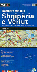
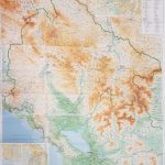
Northern Albania at 1:200,000 in a series of three indexed, GPS compatible touring maps from the Tirana-based cartographic publishers Vektor with a vivid presentation of the country’s topography through contours and bold altitude colouring, plus locations of campsites, beaches and other places of interest. Coverage extends south to Laรง and Peshkopi.Road network is graded into six types, from motorways to minor dirt roads, and indicates border crossings plus driving distances on many local routes. Railway lines are included and local airports are marked. Symbols highlight campsites, beaches, archaeological and historical sites, caves, etc. The maps also show internal administrative divisions and administrative status of towns.Topography is presented by altitude colouring and contour lines, with spot heights and plenty of names of mountain ranges, peaks, etc. National parks and nature reserves are prominently highlighted. The maps have latitude and longitude lines at 10’ intervals. The index is next to the map.Please note: border crossings are prominently marked but beyond topographic colouring no road or other information is provided outside the country’s borders.For the other two titles in this series please click on the series link.

Related Products:
 Best of Albania
 Albania South
 Albania Central
 Albania: Vektor Administrative Prefecture Maps
 Montenegro & North Albania Gizi Map
 Montenegro & North Albania Gizi Wall Map
Korรงa Prefecture
Tirana Prefecture
Berati Prefecture
Bulqiza Prefecture
Delvina Prefecture
Devolli Prefecture
Dibra Prefecture
Elbasani Prefecture
Fieri Prefecture
Gjirokastra Prefecture
Hasi Prefecture
Kavaja Prefecture
Kolonja Prefecture
Kruja Prefecture
Kurbini Prefecture
Lezha Prefecture
Librazhdi Prefecture
Lushnja Prefecture
Mallakastra Prefecture
Mati Prefecture
Mirdita Prefecture
Peqini Prefecture
Pogradeci Prefecture
Puka Prefecture
Saranda Prefecture
Skrapari Prefecture
Shkodra Prefecture
Tepelena Prefecture
Tropoja Prefecture
Vlora Prefecture
Gramshi Prefecture
Kuรงova Prefecture
Pรซrmeti Prefecture
Montenegro & North Albania Gizi Wall Map
Korรงa Prefecture
Tirana Prefecture
Berati Prefecture
Bulqiza Prefecture
Delvina Prefecture
Devolli Prefecture
Dibra Prefecture
Elbasani Prefecture
Fieri Prefecture
Gjirokastra Prefecture
Hasi Prefecture
Kavaja Prefecture
Kolonja Prefecture
Kruja Prefecture
Kurbini Prefecture
Lezha Prefecture
Librazhdi Prefecture
Lushnja Prefecture
Mallakastra Prefecture
Mati Prefecture
Mirdita Prefecture
Peqini Prefecture
Pogradeci Prefecture
Puka Prefecture
Saranda Prefecture
Skrapari Prefecture
Shkodra Prefecture
Tepelena Prefecture
Tropoja Prefecture
Vlora Prefecture
Gramshi Prefecture
Kuรงova Prefecture
Pรซrmeti Prefecture