Disclosure : This site contains affiliate links to products. We may receive a commission for purchases made through these links.
Alaska Reise Know-How
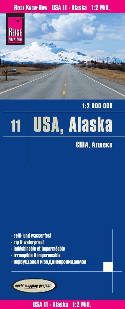
Alaska at 1:2,000,000 in a series of waterproof and tear-resistant, indexed regional maps of USA from Reise Know-How’s highly acclaimed World Mapping Project, combining detailed presentation of the road network with topographic and tourist information. The map is double-sided to provide the best balance between detailed scale and a convenient size sheet. Coverage includes the whole of the Aleutian Islands, with Near and Rat Islands and the panhandle shown as insets. The map presents a very good picture of the states topography with plenty of names of geographical features. National parks and other protected areas are listed in a separate index.Maps in this series have altitude colouring with spot heights to show each region’s topography, with national parks and other protected areas, as well as American Indian Reservations and restricted entry zones clearly marked. Road network indicates toll roads and scenic routes. Driving distances are shown in miles. Railways and, where appropriate, ferry routes are marked. The maps show both names and boundaries of local counties. Symbols highlight a variety of places of interest, including historical sites, amusement parks, natural features, golf courses and wintersport areas, etc. Each map includes an index of localities and has a latitude and longitude grid (in this title at intervals of 2ยฐ). Map legend includes English.To see other titles in this series please click on the series link.

Related Products:
 Florida Reise Know-How
 California Reise Know-How
 USA Northwest – OR, WA Reise Know-How
 Hawaii Reise Know-How
 USA Southeast Reise Know-How
 USA South-Central: Kansas – Oklahoma – Texas Reise-Know-How Map
 USA North-Eastern: Maine to WashingtoN DC (CT, DE, ME, MD, MA, NH, NJ, NY, OH, PA, RI, VT, WV) Reise-Know-How Map
 New England Reise Know-How
 USA North – ID, MT, NE, ND, SD, WY Reise Know-How
 USA: Reise Know-How Regional Touring Maps
 USA Midwest – IL, IN, IA, MI, MN, MO, WI Reise Know-How
 USA Southwest Reise Know-How
 Alaska NGS Wall Map PAPER
 Sulawesi Reise Know-How
 Sumatra Reise-Know-How Map
 Java Reise Know-How
 Ukraine Reise Know-How
 Japan Reise Know-How
 Taiwan Reise Know-How
 Chile Reise Know-How
 Alaska ITMB
 Alaska NGS Wall Map ENCAPSULATED
 Iran Reise Know-How
 Bali – Lombok – Komodo Reise Know-How
 Indonesia: Reise-Know How Regional Maps
 Australia Reise Know-How
 Alaska Recreational Atlas & Gazetteer
 Kazakhstan Reise Know-How
 Alaska F&B
 Baltic States Reise Know-How
 Istria Reise Know-How
 Papua New Guinea – Indonesian Papua & Maluku Islands Reise Know-How
 Canada Central: Western Ontario, Manitoba, Saskatchewan Reise-Know-How Map
 Pakistan Reise Know-How
 Central Asia Reise Know-How
 Sri Lanka Reise Know-How
 Philippines Reise Know-How
 India South Reise Know-How
 Mauritius – Reunion – Rodrigues Reise Know-How
 Egypt Reise Know-How