Disclosure : This site contains affiliate links to products. We may receive a commission for purchases made through these links.
Africa North-East ITMB
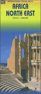
North-western Africa at 1:3,800,000 on an indexed, double-sided map from ITMB with topography presented by altitude colouring. The map divides the region north/south, extending on its northern side from the Mediterranean to the southernmost tip of Eritrea and Ndjamena in Chad, plus westwards to the longitude of 10ยฐ west. The southern half extends to beyond 10ยบ south of the Equator, and westwards to Bangui in the Central African Republic (approx. 18ยบ W). Coverage includes, therefore, the whole of Egypt, Sudan, Libya, Chad, Eritrea, Ethiopia, Djibouti, Somalia (shown without the current political divisions), South Sudan, Central African Republic, Kenya, Uganda, Rwanda and Burundi, plus most of Tanzania and the Democratic Rep. of Congo Topography is presented by altitude colouring with spot heights and names of main mountain ranges. National parks are highlighted. The map shows the network of roads and selected tracks with border crossings. Symbols indicate various places of interest. The map has latitude and longitude lines at 5ยบ intervals and is indexed.To see other titles in this series please click on the series link.

Related Products:
 Africa North ITMB
 Africa East & Central ITMB
 Africa South & Central ITMB
 Africa Northwest ITMB
 Buenos Aires & Argentina North East ITMB
 Africa Equatorial ITMB
 Santiago & Chile North ITMB
 Mexico North-East ITMB
 Africa Lonely Planet Planning Map
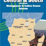 Africa Central & South Map Studio
 Chad ITMB
 India South & North East ITMB
 Bangladesh & India East ITMB
 Cape Verde & West Africa ITMB
 South America North ITMB
 India North East & Kolkata / Calcutta ITMB
 Africa Western ITMB
 Uganda ITMB
 Sydney & Australia East ITMB
 Auckland & North Island ITMB
 Sudan ITMB
 Romania & Moldova ITMB
 Ethiopia & Eritrea ITMB
 Africa Southern ITMB
 Africa: ITMB Sectional Maps
Zambia & Eastern Africa ITMB Road Map
Africa: ITMB Sectional Maps
Zambia & Eastern Africa ITMB Road Map
 Greenland & North Pole ITMB
 China North East
 Alaska ITMB
 Argentina North & Uruguay ITMB
 Paris & France North ITMB
 Shanghai & China South East ITMB
 South East Asia ITMB
 Nova Scotia & Prince Edward Island ITMB
 Mexico North ITMB
 Africa: Eye on Africa – Thirty Years of Africa Images, Selected by Salgado Himself
 Kilimanjaro & Tanzania North ITMB
 Pan-Americana North ITMB Travel Atlas: Alaska to Panama
 China North East Nelles Map