Disclosure : This site contains affiliate links to products. We may receive a commission for purchases made through these links.
Afar Region – Afar (Danakil) Depression
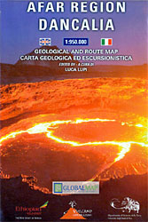
Afar Region including the Afar (Danakil) Depression on a double-sided map from the Italian publishers Litografia Artistica Cartografica presenting the area on contoured, GPS compatible maps at three different scales, with additional geological information.On one side the main map at 1:950,000 covers the Afar Regional State of Ethiopia with the adjoining part of Eritrea including Asmara, plus Djibouti. In its southern part map extends west to include the road connection between Addis Ababa and Awash, and eastwards beyond Jijiga. The map shows main roads, including the Awash – Aseb highway, with driving distances and locations of fuel supplies, plus local roads and tracks. Railway lines are included and domestic airports and sea ports are also marked. Symbols indicate historical and paleontological sites, churches, salt mines, and locations with hospital facilities. Topography is shown by contours with relief shading, permanent or seasonal rivers and lakes, salt flats and plenty of names of various geographical features. Additional colouring provides geological information. Coverage includes Hadar where in 1974 Lucy was found, as well as the Awash and the Yangudi Rassa National Parks.On the reverse the northern part of Afar in Ethiopia and Eritrea is shown in greater detail at 1:600,000, with its central part, the Afar or Danakil Depression, presented at 1:300,000. No additional geological information is included at either scale. Coloured photos, cross-referenced to the maps, illustrate various aspects of the region and a small satellite map shows the Dallol area, one of the hottest places on Earth.All place names are in Latin alphabet only. All three maps have latitude and longitude lines at intervals of 30’. Map legend is in Italian and English.

Related Products:
 The Danakil Diary: Journeys Through Abyssinia 1930-34
 Ethiopia & Eritrea ITMB
 Ethiopia – Eritrea – Djibouti
 Ethiopia – Somalia – Eritrea – Djibouti Reise-Know-How
 Ethiopia – Eritrea – Djibouti Wall Map
 Ethiopia – Eritrea – Djibouti Gizi Map
 Blood Cries Afar: The Forgotten Invasion of England, 1216
 Brasov Region Tourist Map
 Anza-Borrego Desert Region, CA
 Southern Highlands Harvey British Mountain Map XT40
 Snowdonia South Harvey British Mountain Map XT40
 Dolomiti di Sesto Geological Hiking Map
 Kiev Administrative Region
Zaporizhzhia Administrative Region
Zhytomyr Administrative Region
Ternopil Administrative Region
Khmelnytskyi Administrative Region
Lviv Administrative Region
Dnipropetrovsk Administrative Region
Mikolayiv Administrative Region
Rivne Administrative Region
Vinnytsia Administrative Region
Chernihiv Administrative Region
Kharkiv Administrative Region
Cherkasy Administrative Region
Poltava Administrative Region
Kirovohrad Administrative Region
Kherson Administrative Region
Chernivtsi Administrative Region
Sumy Administrative Region
Kiev Administrative Region
Zaporizhzhia Administrative Region
Zhytomyr Administrative Region
Ternopil Administrative Region
Khmelnytskyi Administrative Region
Lviv Administrative Region
Dnipropetrovsk Administrative Region
Mikolayiv Administrative Region
Rivne Administrative Region
Vinnytsia Administrative Region
Chernihiv Administrative Region
Kharkiv Administrative Region
Cherkasy Administrative Region
Poltava Administrative Region
Kirovohrad Administrative Region
Kherson Administrative Region
Chernivtsi Administrative Region
Sumy Administrative Region
 Donetsk Administative Region
Volynska Oblast Administrative Region
Donetsk Administative Region
Volynska Oblast Administrative Region
 Zakarpatska Oblast Administrative Region
Ivano-Frankivsk Administrative Region
Zakarpatska Oblast Administrative Region
Ivano-Frankivsk Administrative Region
 Perth and Region Hema
 Brecon Beacons Harvey British Mountain Map XT40
 Argentina ACA Regional Zone 3 – Region Litoral
 Cairngorms & Lochnagar Harvey British Mountain Map XT40
 Ben Nevis & Glen Coe Harvey British Mountain Map XT40
 Lake District Harvey British Mountain Map XT40