Disclosure : This site contains affiliate links to products. We may receive a commission for purchases made through these links.
Aeolian (Lipari) Islands Kompass 693
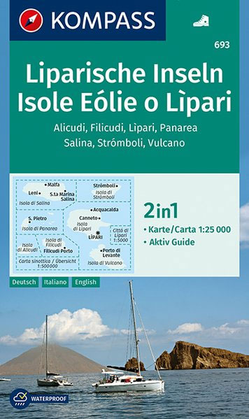
Aeolian (Lipari) Islands on a contoured, GPS compatible hiking and recreational map at 1:25,000 from Kompass printed on durable, waterproof and tear-resistant synthetic paper. The map includes a street plan of Lipari Town and the accompanying booklet has an 11-page English language guide to the islands with descriptions of main places of interest and recommendations for hiking trails.KOMPASS HIKING MAPS OF ITALY:This title is part of an extensive series of walking maps from Kompass covering selected areas of Italy at mainly 1:50,000, with a GPS compatible, contoured topographic base, extensive overprint for hiking routes, various types of accommodation, numerous recreational facilities, places of interest, etc. COVERAGE:The series covers the northern part of the Italian Alps, the lake region of Lombardy, the Dolomites, Italian Riviera, selected parts of Tuscany and Umbria, the Sorrento Peninsula, and the islands of the Tyrrhenian Sea. Coverage of the Dolomites by Kompass at more detailed scales (mainly 1:25,000) is listed on our website in a separate series.CARTOGRAPHY:Contour interval varies according to the terrain from 100m to 25m. All the maps highlight local hiking paths and, where appropriate, long-distance routes or via ferrata trails. Symbols indicate various types of accommodation such as selected inns and hotels, campsites, mountain huts and refuges, etc. Most titles also show cycle or mountain bike trails and/or ski routes. Selected titles include on the reverse panorama drawings of the area, as indicated in the individual descriptions.GPS COMPATIBILITY:Unless indicated to the contrary in the individual description, all the titles are GPS compatible, with latest editions providing a 2-km UTM grid.MAP LEGEND:Map legend includes English.DURABILITY:New editions are now published on waterproof and tear-resistant synthetic paper, as indicated in the individual description.BOOKLETS: PLEASE NOTE BEFORE ORDERING! Many titles come with a booklet describing the area and/or various hiking routes. Unless indicated in the individual description that the booklet includes English, these booklets are in Italian and German only. The booklets are not necessary to use the maps since, as stated above, full English language map legend is provided.Kompass are Europe’s largest publishers of walking maps, with extensive coverage of hiking areas in other countries, all listed on our website.

Related Products:
 Ischia and Procida Islands Kompass 680
 Bolzano and Environs Kompass 54
 Alpi Bellunesi Kompass 77
 Ausseerland – Ennstal – Tauplitz Kompass 68
 Val Venosta / Vinschgau Kompass 52
 Bressanone / Brixen Kompass 56
 Brunico – Dobbiaco – Alta Pusteria Kompass 57
 Bernina – Valmalenco – Sondrio Kompass 93
 Italy: Kompass 50K Hiking Maps
 Adamello – La Presanella Kompass 71
 Regglberg – Latemar – Val d`Ega / Eggental Kompass 630
 Parco Nazionale del Stelvio / NP Stilfser Joch Kompass 072
 South Tyrol – Dolomites 4-Map Set Kompass 699
 Ortles / Ortler – Cevedale Kompass 72
 Val d`Ultimo / Ultental Kompass 052
 Florence – Siena – Chianti Kompass 2458
 Vipiteno / Sterzing Kompass 44
Dolomiti di Sesto / Sextner Dolomiten Kompass 58
Vipiteno / Sterzing Kompass 44
Dolomiti di Sesto / Sextner Dolomiten Kompass 58
 Le Tre Valli Bresciane Kompass 103
 Mont Blanc Kompass 85
 Lago d`Iseo – Valle Trompia – Franciacorta Kompass 106
 Valle di Tures e Aurina / Tauferer Ahrntal Kompass 82
 Ponte di Legno – Alta Val Camonica – Passo del Tonale Kompass 107
 Valle di Non / Nonstal – Passo della Mendola / Mendelpass Kompass 95
 Varallo – Verbania – Lake Orta – NP Val Grande Kompass 97
 Monti Sibillini National Park Kompass 2474
 Cortina d`Ampezzo Kompass 55
 Catinaccio / Rosengarten – Latemar Kompass 629
 Ortles / Ortler – Cevedale Kompass 077
 Trentino 3-Map Set Kompass 683
 Pisa – Livorno – San Miniato – Empoli Kompass 2457
 Val di Funes / Villnรถsstal Kompass 627
Lake Garda – Monte Baldo Kompass 102
Sardinia Central 4-Map Set Kompass 2498
Val di Funes / Villnรถsstal Kompass 627
Lake Garda – Monte Baldo Kompass 102
Sardinia Central 4-Map Set Kompass 2498
 Dolomiti di Brenta – Madonna di Campiglio – Pinzolo – Andalo Kompass 688
 Rovereto – Monte Pasubio Kompass 101
Val Pusteria / Pustertal 3-Map Set Kompass 671
Rovereto – Monte Pasubio Kompass 101
Val Pusteria / Pustertal 3-Map Set Kompass 671
 Sardinia South 4-Map Set Kompass 2499
Alto Garda – Ledro – Valle del Sacra Kompass 096
Sardinia South 4-Map Set Kompass 2499
Alto Garda – Ledro – Valle del Sacra Kompass 096
 Sardinia North 4-Map Set Kompass 2497