Disclosure : This site contains affiliate links to products. We may receive a commission for purchases made through these links.
Admiralty Chart AUS237 – Brisbane River The Bar to Lytton Reach
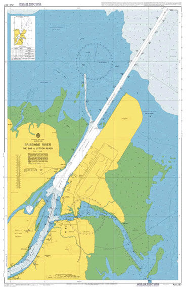
Admiralty standard nautical charts comply with Safety of Life at Sea (SOLAS) regulations and are ideal for professional, commercial and recreational use. Charts within the series consist of a range of scales, useful for passage planning, ocean crossings, coastal navigation and entering port.Standard Admiralty charts are folded to fit in a chart table drawer. If you prefer your Admiralty charts rolled without any folds or creases (suitable for framing), contact us before ordering on +44(0)207 759 7150 or maritime@stanfords.co.uk.
Related Products:
 Admiralty Chart AUS238 – Brisbane River – Lytton Reach to Victoria Bridge
 Admiralty Chart 1185 – River Thames, Sea Reach
 Admiralty Chart AUS168 – River Tamar Long Reach to Launceston
 Admiralty Chart IN3006 – Hugli River, Kukrahatti Reach to Kolkata Docks
 Admiralty Chart 1609 – Thames Estuary – Knock John Channel to Sea Reach
 Admiralty Chart 572 – Essequibo River to Corentyn River
 Admiralty Chart 4177 – Orange River to Table Bay
 Admiralty Chart 2764 – Berbice River to Suriname River
 Admiralty Chart 1386 – Pennington River to Opobo River
 Admiralty Chart 617 – Sherbro River
 Admiralty Chart 2563 – Approaches to Delaware River
 Admiralty Chart AUS242 – Port Bundaberg including Burnett River
 Admiralty Chart 3293 – Nigeria, Bonny River Port Harcourt
 Admiralty Chart 2007 – River Clyde
 Admiralty Chart IN2109 – Tapi River
 Admiralty Chart 834 – Bassein River and Approaches
 Admiralty Chart 4769 – Restigouche River
 Admiralty Chart 658 – Entrance to River Congo
 Admiralty Chart 737 – River Forth – Rosyth to Kincardine
 Admiralty Chart 732 – Pussur River and Approaches
 Admiralty Chart 2495 – Kenmare River
 Admiralty Chart 134 – River Tees to Scarborough
 Admiralty Chart 4792 – St Lawrence River – Port de Montreal
 Admiralty Chart 4171 – Port Shepstone to Tugela River
 Admiralty Chart 1953 – Approaches to the River Dee
 Admiralty Chart 2808 – St Johns River Mayport to Jacksonville
 Admiralty Chart 3857 – Southern Approaches to the Mississippi River
 Admiralty Chart 4132 – Kunene River to Sand table Hill
 Admiralty Chart 1192 – Saint Abb`s Head to the River Tyne
 Admiralty Chart 741 – Plans in the Firth of Forth and River Forth
 Admiralty Chart 1481 – River Tay
 Admiralty Chart 4176 – Walvis Bay to Orange River
 Admiralty Chart 3289 – Bonny River, Port of Onne and Notore Channel
 Admiralty Chart 3288 – Bonny River – Ford Point to Port Harcourt
 Admiralty Chart 4786 – Saint Lawrence River, Port de Quebec
 Admiralty Chart 814 – The Sandheads – Paradip to Raimangal River
 Admiralty Chart IN301 – Approaches to Hugli River
 Admiralty Chart 1385 – Cotonou to Pennington River
 Admiralty Chart 625 – Entrance to Sierra Leone River
 Admiralty Chart 609 – River Gambia Albreda to Kuntaur


