Disclosure : This site contains affiliate links to products. We may receive a commission for purchases made through these links.
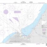
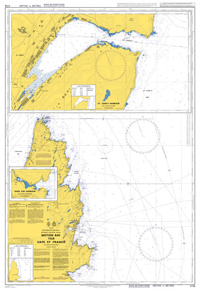
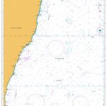
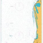
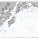
Admiralty Chart 4736 – Motion Bay to/a Cape St Francis
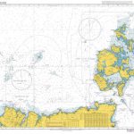
Wonderful 72x105cm sea chart of the waters around Britain and Ireland. The chart shows the depth of the sea, clearly showing the areas which, but for small depth of water, would be land. Flooded lands and sunken islands, the stuff of legendsยฟ Lighthouses are also shown. A decorative map for anyone interested in the sea.

Related Products:
 Admiralty Chart 2628 – Portsmouth Harbour, Northern Part
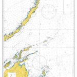
 CHS Chart 4846 – Motion Bay to Cape St Francis
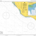
 Admiralty Chart 4155 – Cape St Blaize to Cape St Francis
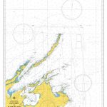
 Admiralty Chart 4156 – Cape St Francis to Great Fish Point
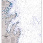
 C68 Cape Wrath to Wick and the Orkney Islands
 CHS Chart 4850 – Cape St Francis to Baccalieu Island and Heart`s Content
 Admiralty Chart 775 – Cape Arnauti to Cape Limniti and Cape Aspro
 Admiralty Chart 4639 – Kermadec Islands to East Cape
 Admiralty Chart AUS328 – Montebello Islands to North West Cape
 Admiralty Chart 796 – Cape Eloea and Stazousa Point to Cape Andreas
 Admiralty Chart AUS349 – Cape Nelson to Cape Schanck
 Admiralty Chart AUS795 – South East Cape to Cape Pillar
 Admiralty Chart 4153 – Cape Agulhas to Cape St Blaize
 Admiralty Chart 4725 – North West Cape to Cape Leeuwin
 Admiralty Chart 2865 – Cape Romain to Cape Canaveral
 Admiralty Chart AUS715 – Cape Arnhem to Cape Wessel
 Admiralty Chart AUS348 – Cape Martin to Cape Nelson
 Admiralty Chart AUS801 – Cape Schanck to Cape Liptrap
 Admiralty Chart AUS788 – Cape Otway to Cape Schanck
 Admiralty Chart 3711 – Cape Adare to Cape Daniell
 Admiralty Chart 3714 – Cape Adare and Cape Hallett
 Admiralty Chart 3113 – Cape Three Points to Cape Coast
 Admiralty Chart 4733 – Cape Race to Cape Freels
 Admiralty Chart AUS306 – Cape Grey to Cape Wessel and Elcho Island
 Admiralty Chart 4731 – Pointe Amour to Cape Whittle and Cape St. George
 Admiralty Chart 4643 – Cape Howe to Cape Moreton
 Admiralty Chart AUS755 – Cape Peron to Cape Naturaliste
 Admiralty Chart 2864 – Cape Hatteras to Cape Romain
 Admiralty Chart NZ55 – Cape Runaway to Table Cape
 Admiralty Chart 850 – Cape Aspro to Cape Pyla
 Admiralty Chart 851 – Cape Kiti to Cape Eloea
 Admiralty Chart 324 – Cape North to Cape Freels including Outer Approaches to Strait of Belle Isle
 Admiralty Chart NZ52 – Cape Brett to Cuvier Island
 Admiralty Chart NZ56 – Table Cape to Blackhead Point
 Admiralty Chart 4976 – Cape Saint Elias to Shumagin Islands
 Admiralty Chart 1954 – Cape Wrath to Pentland Firth including the Orkney Islands
 Admiralty Chart 4644 – Cape Otway to Cape Howe including Tasmania
 Admiralty Chart IN260 – Kochi to Cape Comorin
 Admiralty Chart 3096 – Cape Cod Bay
 M23 Adriatic Sea Passage Chart 2020