Disclosure : This site contains affiliate links to products. We may receive a commission for purchases made through these links.
Achaia Anavasi 13
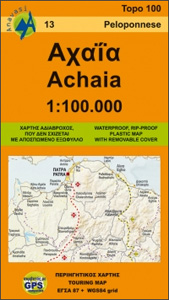
Achaia province with a plan of central Patras in a series from Anavasi covering selected popular areas of central mainland Greece and the Peloponnese with GPS compatible, detailed topographic road maps at 1:100,000, printed on waterproof and tear-resistant paper. The plan of central Patras is conveniently places on the detachable map cover.Contours at 100m intervals (or 50m where indicated in the individual descriptions), relief shading and spot heights present the topography, and the maps also show variations in vegetation: forest, shrubbery, orchards, and vineyards. Road network includes minor unsurfaced roads, indicating those in poor condition. Intermediate distances are marked on main and secondary routes. Archaeological or historical sites and other places of interest are highlighted, with symbols marking mountain refuges, caves, thermal spas, etc. Names of town, villages, and most geographical features and places of interest are in both Greek and Latin alphabet. The maps have both UTM grid lines and ticks plus crosshairs for latitude and longitude lines at 5’ intervals. Map legend includes English. The double index on the reverse of the maps is in both scripts.

Related Products:
 Fokidha Anavasi 07
 Messinia Anavasi 17
Greece: Anavasi Touring Maps of the Mainland and Peloponnese
Messinia Anavasi 17
Greece: Anavasi Touring Maps of the Mainland and Peloponnese
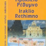 Iraklion – Rethymnon – Central Crete Anavasi 93
 Chania – Gavdos Anavasi 94
 Greece: Anavasi 100K Touring Maps of Crete
 Lasithi – Eastern Crete Anavasi 92
 Mainalo – Artemisio – Lyrkeio – Farmakas – Ktenias Anavasi 8.5
 Peloponnese Anavasi Regional Map R2
 Macedonia Anavasi Regional Map R4
 Peloponnese Anavasi Road Atlas
 Attica – Boeotia Anavasi 10
Greece: Anavasi 200K/250K Road Maps
Attica – Boeotia Anavasi 10
Greece: Anavasi 200K/250K Road Maps
 Mt Dikti – Mt Selena Anavasi 11.15
 Northern Agrafa – Plastira Lake Anavasi 4.1
 Bulgaria Cartographia Road Map
 Evia / Euboea – Skyros Anavasi 04
 Karpathos – Saria Anavasi 10.50
 Milos – Kimolos – Polyvos Anavasi 10.45
 Rhodes & Symi Anavasi 10.38
 Skyros Anavasi 10.14
 Central Greece – Thessaly – Epirus Anavasi Regional Map R3
 Kythnos Anavasi 10.44
 Mani Anavasi 8.4
 Macedonia Wall Map
 Paros – Antiparos Anavasi 10.23
 Greece: Anavasi Hiking Maps of Crete
 Macedonia Gizi Map
 Lefkada Anavasi 9.1
 Athens Anavasi Pocket Map
 Cephalonia / Kefalonia – Ithaca Anavasi 9.3
 Lousios Anavasi 8.51
 Mt Parnitha Anavasi 1.1
 Mt Kyllinin / Ziria Anavasi 8.31
 Amorgos Anavasi 10.27
 Greece: Attika and Central Greece Road Atlas
 Pakistan ITMB
 Chios – Psara – Inouses Anavasi 10.31
 Spetses Anavasi 10.30
 Andros Anavasi 10.21